You are here: Home > Network List > TA - USArray Transportable Network (new EarthScope stations) Stations List
> Station E62A Clayton Lake, ME, USA > Earthquake Result Viewer
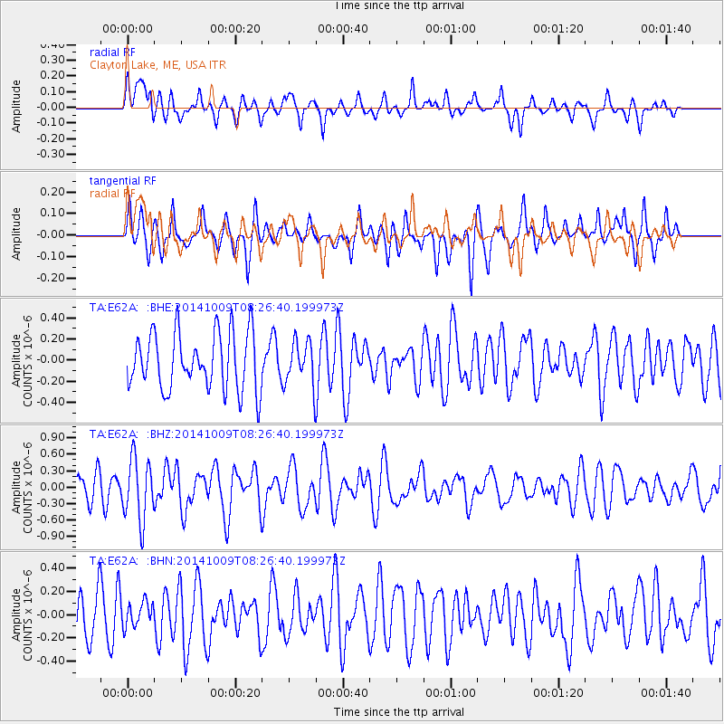
E62A Clayton Lake, ME, USA - Earthquake Result Viewer
*The percent match for this event was below the threshold and hence no stack was calculated.
| Earthquake location: |
Southern East Pacific Rise |
| Earthquake latitude/longitude: |
-32.7/-111.6 |
| Earthquake time(UTC): |
2014/10/09 (282) 08:14:23 GMT |
| Earthquake Depth: |
10 km |
| Earthquake Magnitude: |
5.6 MB |
| Earthquake Catalog/Contributor: |
NEIC PDE/NEIC COMCAT |
|
| Network: |
TA USArray Transportable Network (new EarthScope stations) |
| Station: |
E62A Clayton Lake, ME, USA |
| Lat/Lon: |
46.62 N/69.52 W |
| Elevation: |
356 m |
|
| Distance: |
87.6 deg |
| Az: |
27.555 deg |
| Baz: |
214.477 deg |
| Ray Param: |
$rayparam |
*The percent match for this event was below the threshold and hence was not used in the summary stack. |
|
| Radial Match: |
60.28466 % |
| Radial Bump: |
400 |
| Transverse Match: |
57.177177 % |
| Transverse Bump: |
384 |
| SOD ConfigId: |
803114 |
| Insert Time: |
2014-10-23 08:41:17.190 +0000 |
| GWidth: |
2.5 |
| Max Bumps: |
400 |
| Tol: |
0.001 |
|
Signal To Noise
| Channel | StoN | STA | LTA |
| TA:E62A: :BHZ:20141009T08:26:40.199973Z | 2.1621995 | 5.6680847E-7 | 2.621444E-7 |
| TA:E62A: :BHN:20141009T08:26:40.199973Z | 0.5374309 | 1.05292706E-7 | 1.9591862E-7 |
| TA:E62A: :BHE:20141009T08:26:40.199973Z | 0.76395804 | 2.0644374E-7 | 2.7022918E-7 |
| Arrivals |
| Ps | |
| PpPs | |
| PsPs/PpSs | |


