You are here: Home > Network List > TA - USArray Transportable Network (new EarthScope stations) Stations List
> Station MSTX Muleshoe, TX, USA > Earthquake Result Viewer
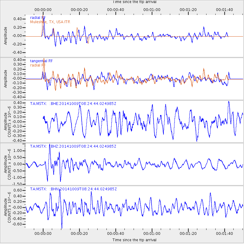
MSTX Muleshoe, TX, USA - Earthquake Result Viewer
*The percent match for this event was below the threshold and hence no stack was calculated.
| Earthquake location: |
Southern East Pacific Rise |
| Earthquake latitude/longitude: |
-32.7/-111.6 |
| Earthquake time(UTC): |
2014/10/09 (282) 08:14:23 GMT |
| Earthquake Depth: |
10 km |
| Earthquake Magnitude: |
5.6 MB |
| Earthquake Catalog/Contributor: |
NEIC PDE/NEIC COMCAT |
|
| Network: |
TA USArray Transportable Network (new EarthScope stations) |
| Station: |
MSTX Muleshoe, TX, USA |
| Lat/Lon: |
33.97 N/102.77 W |
| Elevation: |
1167 m |
|
| Distance: |
66.8 deg |
| Az: |
8.004 deg |
| Baz: |
188.124 deg |
| Ray Param: |
$rayparam |
*The percent match for this event was below the threshold and hence was not used in the summary stack. |
|
| Radial Match: |
75.60903 % |
| Radial Bump: |
400 |
| Transverse Match: |
62.49787 % |
| Transverse Bump: |
400 |
| SOD ConfigId: |
803114 |
| Insert Time: |
2014-10-23 08:44:03.758 +0000 |
| GWidth: |
2.5 |
| Max Bumps: |
400 |
| Tol: |
0.001 |
|
Signal To Noise
| Channel | StoN | STA | LTA |
| TA:MSTX: :BHZ:20141009T08:24:44.024985Z | 5.782306 | 5.8629456E-7 | 1.013946E-7 |
| TA:MSTX: :BHN:20141009T08:24:44.024985Z | 2.3607967 | 2.6116456E-7 | 1.1062561E-7 |
| TA:MSTX: :BHE:20141009T08:24:44.024985Z | 1.0036751 | 1.5469888E-7 | 1.5413242E-7 |
| Arrivals |
| Ps | |
| PpPs | |
| PsPs/PpSs | |


