You are here: Home > Network List > TA - USArray Transportable Network (new EarthScope stations) Stations List
> Station P54A Burton, WV, USA > Earthquake Result Viewer
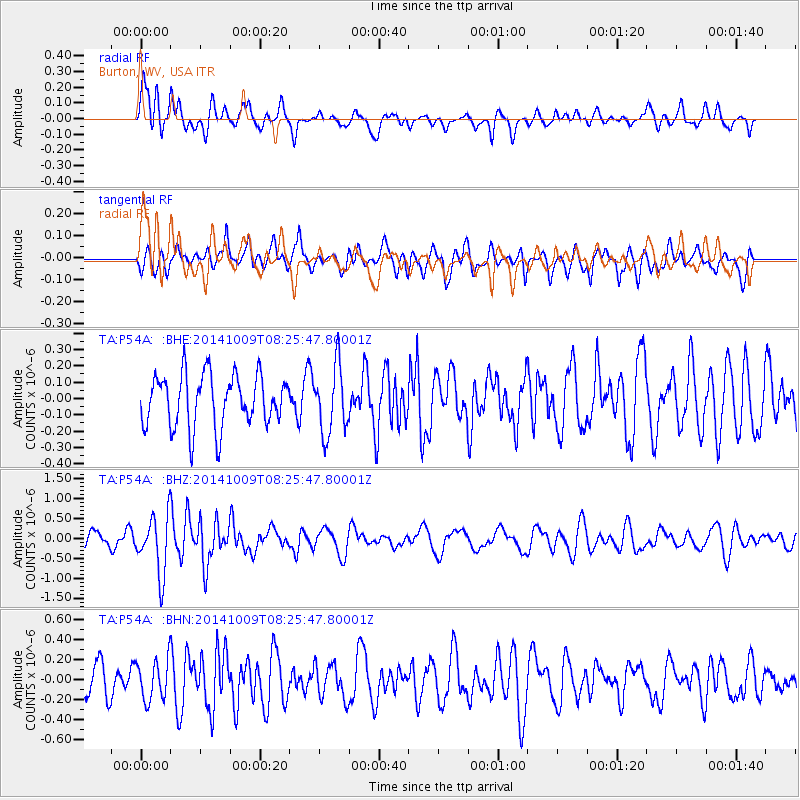
P54A Burton, WV, USA - Earthquake Result Viewer
*The percent match for this event was below the threshold and hence no stack was calculated.
| Earthquake location: |
Southern East Pacific Rise |
| Earthquake latitude/longitude: |
-32.7/-111.6 |
| Earthquake time(UTC): |
2014/10/09 (282) 08:14:23 GMT |
| Earthquake Depth: |
10 km |
| Earthquake Magnitude: |
5.6 MB |
| Earthquake Catalog/Contributor: |
NEIC PDE/NEIC COMCAT |
|
| Network: |
TA USArray Transportable Network (new EarthScope stations) |
| Station: |
P54A Burton, WV, USA |
| Lat/Lon: |
39.61 N/80.48 W |
| Elevation: |
473 m |
|
| Distance: |
77.5 deg |
| Az: |
24.163 deg |
| Baz: |
206.547 deg |
| Ray Param: |
$rayparam |
*The percent match for this event was below the threshold and hence was not used in the summary stack. |
|
| Radial Match: |
62.61844 % |
| Radial Bump: |
400 |
| Transverse Match: |
60.55473 % |
| Transverse Bump: |
400 |
| SOD ConfigId: |
803114 |
| Insert Time: |
2014-10-23 08:45:20.278 +0000 |
| GWidth: |
2.5 |
| Max Bumps: |
400 |
| Tol: |
0.001 |
|
Signal To Noise
| Channel | StoN | STA | LTA |
| TA:P54A: :BHZ:20141009T08:25:47.80001Z | 2.897797 | 7.372568E-7 | 2.5441975E-7 |
| TA:P54A: :BHN:20141009T08:25:47.80001Z | 0.9906353 | 2.0380631E-7 | 2.0573295E-7 |
| TA:P54A: :BHE:20141009T08:25:47.80001Z | 1.3119185 | 2.0778111E-7 | 1.5837959E-7 |
| Arrivals |
| Ps | |
| PpPs | |
| PsPs/PpSs | |


