You are here: Home > Network List > AK - Alaska Regional Network Stations List
> Station CYK Cape Yakataga, AK, USA > Earthquake Result Viewer
CYK Cape Yakataga, AK, USA - Earthquake Result Viewer
| Earthquake location: |
New Britain Region, P.N.G. |
| Earthquake latitude/longitude: |
-5.5/151.9 |
| Earthquake time(UTC): |
2015/05/05 (125) 01:44:07 GMT |
| Earthquake Depth: |
63 km |
| Earthquake Magnitude: |
7.4 MWW, 7.5 MI |
| Earthquake Catalog/Contributor: |
NEIC PDE/NEIC COMCAT |
|
| Network: |
AK Alaska Regional Network |
| Station: |
CYK Cape Yakataga, AK, USA |
| Lat/Lon: |
60.08 N/142.49 W |
| Elevation: |
23 m |
|
| Distance: |
82.9 deg |
| Az: |
27.389 deg |
| Baz: |
246.0 deg |
| Ray Param: |
0.04645157 |
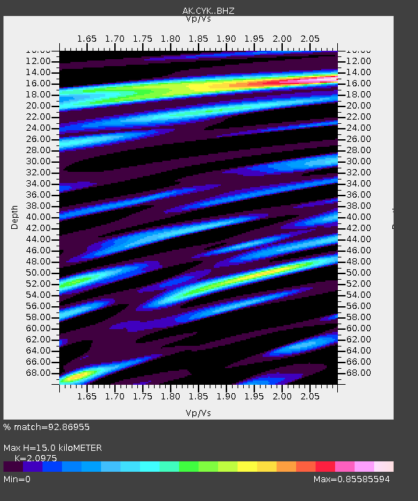
| Estimated Moho Depth: |
15.0 km |
| Estimated Crust Vp/Vs: |
2.10 |
| Assumed Crust Vp: |
6.566 km/s |
| Estimated Crust Vs: |
3.13 km/s |
| Estimated Crust Poisson's Ratio: |
0.35 |
|
| Radial Match: |
92.86955 % |
| Radial Bump: |
400 |
| Transverse Match: |
79.949135 % |
| Transverse Bump: |
400 |
| SOD ConfigId: |
7422571 |
| Insert Time: |
2019-04-18 15:57:36.175 +0000 |
| GWidth: |
2.5 |
| Max Bumps: |
400 |
| Tol: |
0.001 |
|

Signal To Noise
| Channel | StoN | STA | LTA |
| AK:CYK: :BHZ:20150505T01:55:54.948005Z | 6.2086287 | 1.8649812E-6 | 3.0038535E-7 |
| AK:CYK: :BHN:20150505T01:55:54.948005Z | 1.5541618 | 4.3569327E-7 | 2.803397E-7 |
| AK:CYK: :BHE:20150505T01:55:54.948005Z | 1.9153236 | 6.0540435E-7 | 3.1608462E-7 |
| Arrivals |
| Ps | 2.6 SECOND |
| PpPs | 6.9 SECOND |
| PsPs/PpSs | 9.5 SECOND |


