You are here: Home > Network List > TA - USArray Transportable Network (new EarthScope stations) Stations List
> Station W57A Gilead, NC, USA > Earthquake Result Viewer
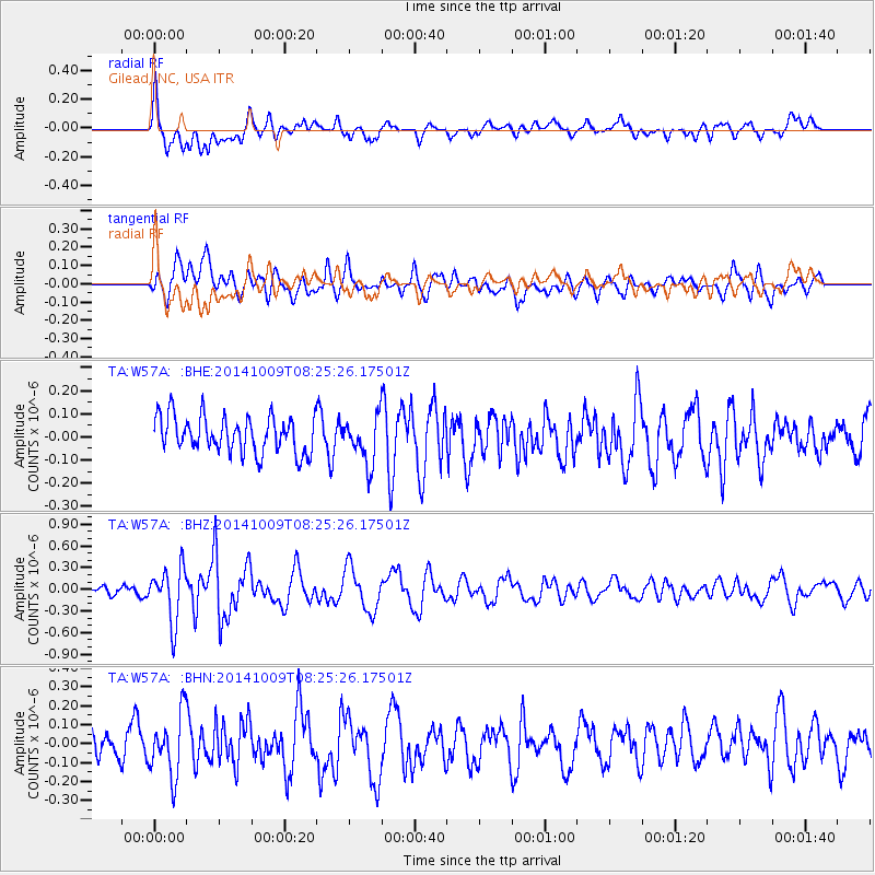
W57A Gilead, NC, USA - Earthquake Result Viewer
*The percent match for this event was below the threshold and hence no stack was calculated.
| Earthquake location: |
Southern East Pacific Rise |
| Earthquake latitude/longitude: |
-32.7/-111.6 |
| Earthquake time(UTC): |
2014/10/09 (282) 08:14:23 GMT |
| Earthquake Depth: |
10 km |
| Earthquake Magnitude: |
5.6 MB |
| Earthquake Catalog/Contributor: |
NEIC PDE/NEIC COMCAT |
|
| Network: |
TA USArray Transportable Network (new EarthScope stations) |
| Station: |
W57A Gilead, NC, USA |
| Lat/Lon: |
35.15 N/79.99 W |
| Elevation: |
85 m |
|
| Distance: |
73.7 deg |
| Az: |
26.604 deg |
| Baz: |
207.449 deg |
| Ray Param: |
$rayparam |
*The percent match for this event was below the threshold and hence was not used in the summary stack. |
|
| Radial Match: |
70.91593 % |
| Radial Bump: |
400 |
| Transverse Match: |
53.80814 % |
| Transverse Bump: |
400 |
| SOD ConfigId: |
803114 |
| Insert Time: |
2014-10-23 08:47:57.216 +0000 |
| GWidth: |
2.5 |
| Max Bumps: |
400 |
| Tol: |
0.001 |
|
Signal To Noise
| Channel | StoN | STA | LTA |
| TA:W57A: :BHZ:20141009T08:25:26.17501Z | 4.0219383 | 3.7221332E-7 | 9.2545754E-8 |
| TA:W57A: :BHN:20141009T08:25:26.17501Z | 2.0350184 | 1.6323544E-7 | 8.021325E-8 |
| TA:W57A: :BHE:20141009T08:25:26.17501Z | 1.2676383 | 1.00304675E-7 | 7.9127204E-8 |
| Arrivals |
| Ps | |
| PpPs | |
| PsPs/PpSs | |


