You are here: Home > Network List > US - United States National Seismic Network Stations List
> Station MSO Missoula, Montana, USA > Earthquake Result Viewer
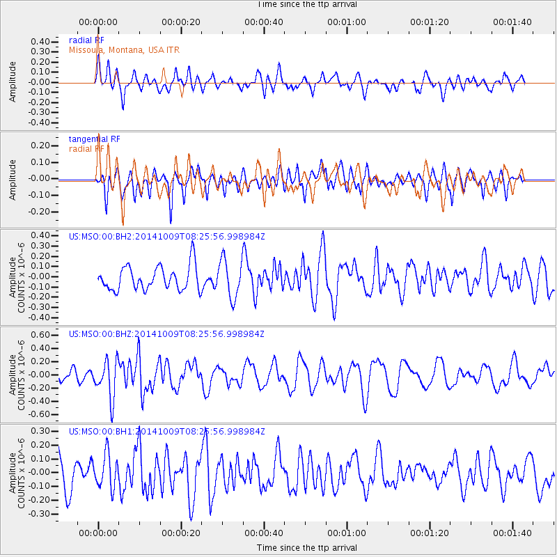
MSO Missoula, Montana, USA - Earthquake Result Viewer
*The percent match for this event was below the threshold and hence no stack was calculated.
| Earthquake location: |
Southern East Pacific Rise |
| Earthquake latitude/longitude: |
-32.7/-111.6 |
| Earthquake time(UTC): |
2014/10/09 (282) 08:14:23 GMT |
| Earthquake Depth: |
10 km |
| Earthquake Magnitude: |
5.6 MB |
| Earthquake Catalog/Contributor: |
NEIC PDE/NEIC COMCAT |
|
| Network: |
US United States National Seismic Network |
| Station: |
MSO Missoula, Montana, USA |
| Lat/Lon: |
46.83 N/113.94 W |
| Elevation: |
1264 m |
|
| Distance: |
79.2 deg |
| Az: |
358.386 deg |
| Baz: |
178.017 deg |
| Ray Param: |
$rayparam |
*The percent match for this event was below the threshold and hence was not used in the summary stack. |
|
| Radial Match: |
61.08309 % |
| Radial Bump: |
400 |
| Transverse Match: |
42.660675 % |
| Transverse Bump: |
400 |
| SOD ConfigId: |
803114 |
| Insert Time: |
2014-10-23 08:50:31.493 +0000 |
| GWidth: |
2.5 |
| Max Bumps: |
400 |
| Tol: |
0.001 |
|
Signal To Noise
| Channel | StoN | STA | LTA |
| US:MSO:00:BHZ:20141009T08:25:56.998984Z | 1.831103 | 2.9934617E-7 | 1.6347862E-7 |
| US:MSO:00:BH1:20141009T08:25:56.998984Z | 0.9633149 | 1.2656332E-7 | 1.3138312E-7 |
| US:MSO:00:BH2:20141009T08:25:56.998984Z | 1.650393 | 1.9303515E-7 | 1.1696314E-7 |
| Arrivals |
| Ps | |
| PpPs | |
| PsPs/PpSs | |


