You are here: Home > Network List > AT - Alaska Tsunami Warning Seismic System Stations List
> Station SVW2 Sparrevohn, Alaska > Earthquake Result Viewer
SVW2 Sparrevohn, Alaska - Earthquake Result Viewer
| Earthquake location: |
New Britain Region, P.N.G. |
| Earthquake latitude/longitude: |
-5.5/151.9 |
| Earthquake time(UTC): |
2015/05/05 (125) 01:44:07 GMT |
| Earthquake Depth: |
63 km |
| Earthquake Magnitude: |
7.4 MWW, 7.5 MI |
| Earthquake Catalog/Contributor: |
NEIC PDE/NEIC COMCAT |
|
| Network: |
AT Alaska Tsunami Warning Seismic System |
| Station: |
SVW2 Sparrevohn, Alaska |
| Lat/Lon: |
61.11 N/155.62 W |
| Elevation: |
499 m |
|
| Distance: |
77.8 deg |
| Az: |
23.203 deg |
| Baz: |
233.861 deg |
| Ray Param: |
0.04994647 |
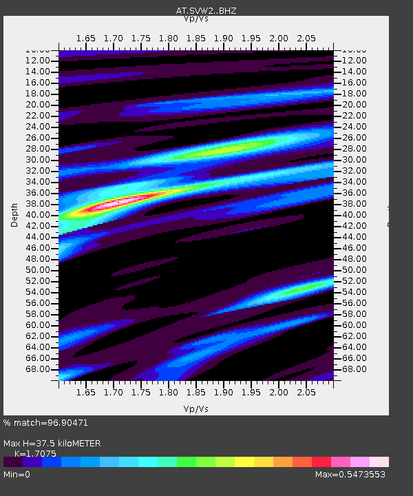
| Estimated Moho Depth: |
37.5 km |
| Estimated Crust Vp/Vs: |
1.71 |
| Assumed Crust Vp: |
6.566 km/s |
| Estimated Crust Vs: |
3.845 km/s |
| Estimated Crust Poisson's Ratio: |
0.24 |
|
| Radial Match: |
96.90471 % |
| Radial Bump: |
225 |
| Transverse Match: |
42.960266 % |
| Transverse Bump: |
308 |
| SOD ConfigId: |
7422571 |
| Insert Time: |
2019-04-18 15:58:30.270 +0000 |
| GWidth: |
2.5 |
| Max Bumps: |
400 |
| Tol: |
0.001 |
|

Signal To Noise
| Channel | StoN | STA | LTA |
| AT:SVW2: :BHZ:20150505T01:55:27.70002Z | 11.594947 | 1.9575405E-6 | 1.6882703E-7 |
| AT:SVW2: :BHN:20150505T01:55:27.70002Z | 1.1426098 | 2.6023808E-6 | 2.2775762E-6 |
| AT:SVW2: :BHE:20150505T01:55:27.70002Z | 1.0803721 | 1.3826917E-6 | 1.2798292E-6 |
| Arrivals |
| Ps | 4.2 SECOND |
| PpPs | 15 SECOND |
| PsPs/PpSs | 19 SECOND |


