You are here: Home > Network List > AV - Alaska Volcano Observatory Stations List
> Station SPCP Crater Peak Broadband, Mount Spurr, Alaska > Earthquake Result Viewer
SPCP Crater Peak Broadband, Mount Spurr, Alaska - Earthquake Result Viewer
| Earthquake location: |
New Britain Region, P.N.G. |
| Earthquake latitude/longitude: |
-5.5/151.9 |
| Earthquake time(UTC): |
2015/05/05 (125) 01:44:07 GMT |
| Earthquake Depth: |
63 km |
| Earthquake Magnitude: |
7.4 MWW, 7.5 MI |
| Earthquake Catalog/Contributor: |
NEIC PDE/NEIC COMCAT |
|
| Network: |
AV Alaska Volcano Observatory |
| Station: |
SPCP Crater Peak Broadband, Mount Spurr, Alaska |
| Lat/Lon: |
61.27 N/152.15 W |
| Elevation: |
1616 m |
|
| Distance: |
79.3 deg |
| Az: |
24.042 deg |
| Baz: |
237.06 deg |
| Ray Param: |
0.04894663 |
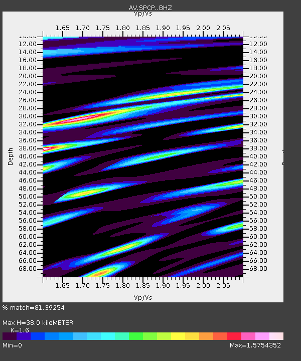
| Estimated Moho Depth: |
38.0 km |
| Estimated Crust Vp/Vs: |
1.60 |
| Assumed Crust Vp: |
6.566 km/s |
| Estimated Crust Vs: |
4.104 km/s |
| Estimated Crust Poisson's Ratio: |
0.18 |
|
| Radial Match: |
81.39254 % |
| Radial Bump: |
400 |
| Transverse Match: |
84.922356 % |
| Transverse Bump: |
400 |
| SOD ConfigId: |
7422571 |
| Insert Time: |
2019-04-18 15:58:48.954 +0000 |
| GWidth: |
2.5 |
| Max Bumps: |
400 |
| Tol: |
0.001 |
|

Signal To Noise
| Channel | StoN | STA | LTA |
| AV:SPCP: :BHZ:20150505T01:55:35.779976Z | 9.648646 | 1.5624753E-6 | 1.6193725E-7 |
| AV:SPCP: :BHN:20150505T01:55:35.779976Z | 4.5300765 | 8.809788E-7 | 1.9447327E-7 |
| AV:SPCP: :BHE:20150505T01:55:35.779976Z | 1.1760507 | 3.1425452E-7 | 2.6721173E-7 |
| Arrivals |
| Ps | 3.6 SECOND |
| PpPs | 15 SECOND |
| PsPs/PpSs | 18 SECOND |


