You are here: Home > Network List > CI - Caltech Regional Seismic Network Stations List
> Station BFS Mt Baldy Forest Station > Earthquake Result Viewer
BFS Mt Baldy Forest Station - Earthquake Result Viewer
| Earthquake location: |
New Britain Region, P.N.G. |
| Earthquake latitude/longitude: |
-5.5/151.9 |
| Earthquake time(UTC): |
2015/05/05 (125) 01:44:07 GMT |
| Earthquake Depth: |
63 km |
| Earthquake Magnitude: |
7.4 MWW, 7.5 MI |
| Earthquake Catalog/Contributor: |
NEIC PDE/NEIC COMCAT |
|
| Network: |
CI Caltech Regional Seismic Network |
| Station: |
BFS Mt Baldy Forest Station |
| Lat/Lon: |
34.24 N/117.66 W |
| Elevation: |
1312 m |
|
| Distance: |
93.4 deg |
| Az: |
56.088 deg |
| Baz: |
265.704 deg |
| Ray Param: |
0.04123637 |
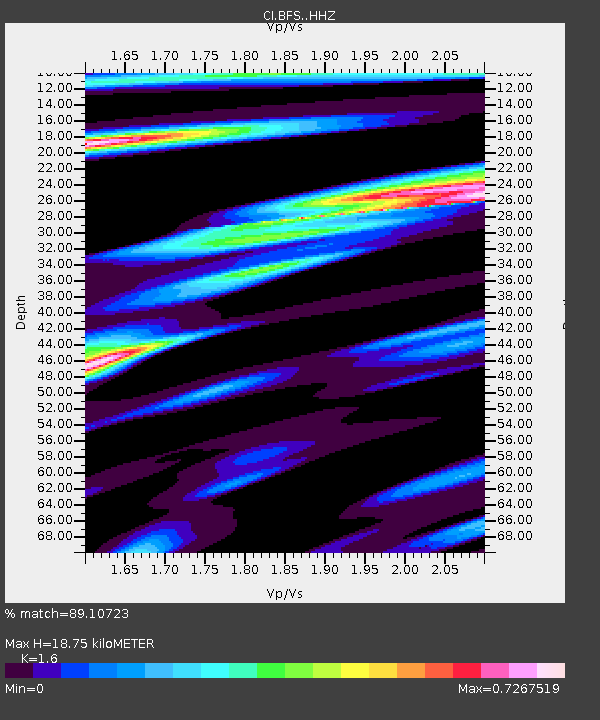
| Estimated Moho Depth: |
18.75 km |
| Estimated Crust Vp/Vs: |
1.60 |
| Assumed Crust Vp: |
6.276 km/s |
| Estimated Crust Vs: |
3.922 km/s |
| Estimated Crust Poisson's Ratio: |
0.18 |
|
| Radial Match: |
89.10723 % |
| Radial Bump: |
400 |
| Transverse Match: |
80.318695 % |
| Transverse Bump: |
400 |
| SOD ConfigId: |
7422571 |
| Insert Time: |
2019-04-18 15:59:32.738 +0000 |
| GWidth: |
2.5 |
| Max Bumps: |
400 |
| Tol: |
0.001 |
|

Signal To Noise
| Channel | StoN | STA | LTA |
| CI:BFS: :HHZ:20150505T01:56:45.427986Z | 3.659176 | 8.2816223E-7 | 2.2632479E-7 |
| CI:BFS: :HHN:20150505T01:56:45.427986Z | 1.6049178 | 3.4439626E-7 | 2.145881E-7 |
| CI:BFS: :HHE:20150505T01:56:45.427986Z | 1.7445438 | 3.2894465E-7 | 1.8855626E-7 |
| Arrivals |
| Ps | 1.8 SECOND |
| PpPs | 7.6 SECOND |
| PsPs/PpSs | 9.4 SECOND |


