You are here: Home > Network List > IU - Global Seismograph Network (GSN - IRIS/USGS) Stations List
> Station GRFO Grafenberg, Germany > Earthquake Result Viewer
GRFO Grafenberg, Germany - Earthquake Result Viewer

| Earthquake location: |
Xizang |
| Earthquake latitude/longitude: |
35.1/87.3 |
| Earthquake time(UTC): |
1997/11/08 (312) 10:02:52 GMT |
| Earthquake Depth: |
33 km |
| Earthquake Magnitude: |
6.2 MB, 7.9 MS, 7.7 UNKNOWN, 7.6 MW |
| Earthquake Catalog/Contributor: |
WHDF/NEIC |
|
| Network: |
IU Global Seismograph Network (GSN - IRIS/USGS) |
| Station: |
GRFO Grafenberg, Germany |
| Lat/Lon: |
49.69 N/11.22 E |
| Elevation: |
425 m |
|
| Distance: |
55.7 deg |
| Az: |
310.295 deg |
| Baz: |
74.445 deg |
| Ray Param: |
0.06453449 |
| Estimated Moho Depth: |
32.75 km |
| Estimated Crust Vp/Vs: |
1.69 |
| Assumed Crust Vp: |
6.182 km/s |
| Estimated Crust Vs: |
3.664 km/s |
| Estimated Crust Poisson's Ratio: |
0.23 |
|
| Radial Match: |
96.19848 % |
| Radial Bump: |
347 |
| Transverse Match: |
91.54367 % |
| Transverse Bump: |
400 |
| SOD ConfigId: |
6273 |
| Insert Time: |
2010-03-02 02:17:13.922 +0000 |
| GWidth: |
2.5 |
| Max Bumps: |
400 |
| Tol: |
0.001 |
|
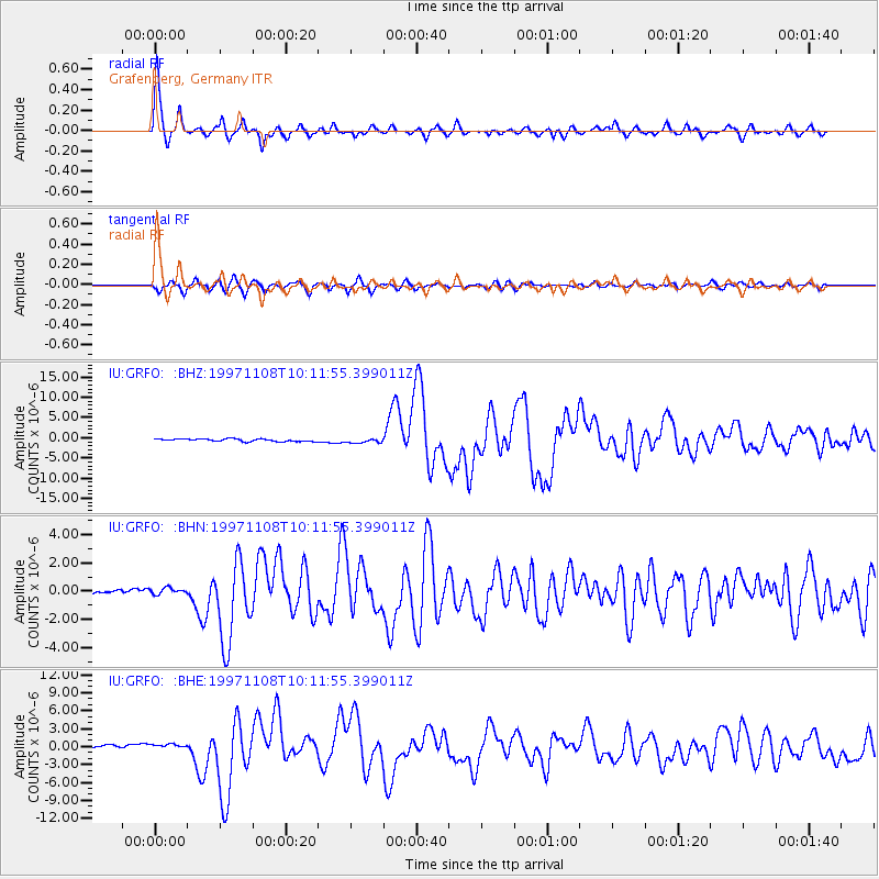
Signal To Noise
| Channel | StoN | STA | LTA |
| IU:GRFO: :BHN:19971108T10:11:55.399011Z | 0.828166 | 2.4355958E-7 | 2.9409512E-7 |
| IU:GRFO: :BHE:19971108T10:11:55.399011Z | 1.6203663 | 3.880592E-7 | 2.3948854E-7 |
| IU:GRFO: :BHZ:19971108T10:11:55.399011Z | 1.5818783 | 5.0580473E-7 | 3.1974946E-7 |
| Arrivals |
| Ps | 3.8 SECOND |
| PpPs | 14 SECOND |
| PsPs/PpSs | 17 SECOND |


