You are here: Home > Network List > CI - Caltech Regional Seismic Network Stations List
> Station SMM Simmler, CA, USA > Earthquake Result Viewer
SMM Simmler, CA, USA - Earthquake Result Viewer
| Earthquake location: |
New Britain Region, P.N.G. |
| Earthquake latitude/longitude: |
-5.5/151.9 |
| Earthquake time(UTC): |
2015/05/05 (125) 01:44:07 GMT |
| Earthquake Depth: |
63 km |
| Earthquake Magnitude: |
7.4 MWW, 7.5 MI |
| Earthquake Catalog/Contributor: |
NEIC PDE/NEIC COMCAT |
|
| Network: |
CI Caltech Regional Seismic Network |
| Station: |
SMM Simmler, CA, USA |
| Lat/Lon: |
35.31 N/120.00 W |
| Elevation: |
599 m |
|
| Distance: |
91.6 deg |
| Az: |
54.853 deg |
| Baz: |
264.431 deg |
| Ray Param: |
0.041564308 |
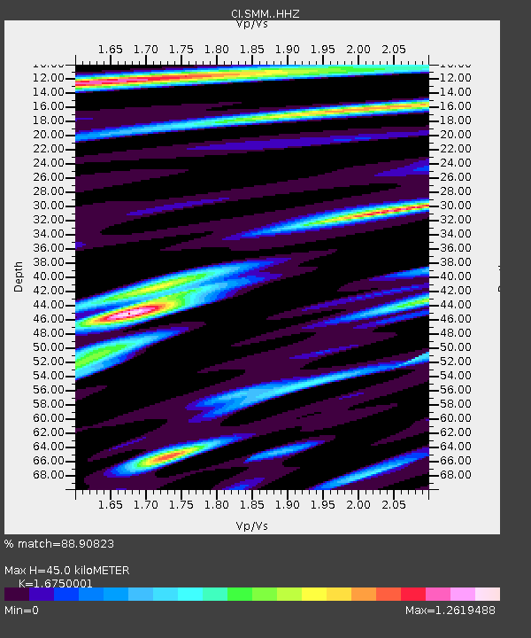
| Estimated Moho Depth: |
45.0 km |
| Estimated Crust Vp/Vs: |
1.68 |
| Assumed Crust Vp: |
6.1 km/s |
| Estimated Crust Vs: |
3.642 km/s |
| Estimated Crust Poisson's Ratio: |
0.22 |
|
| Radial Match: |
88.90823 % |
| Radial Bump: |
400 |
| Transverse Match: |
71.79424 % |
| Transverse Bump: |
400 |
| SOD ConfigId: |
7422571 |
| Insert Time: |
2019-04-18 15:59:57.812 +0000 |
| GWidth: |
2.5 |
| Max Bumps: |
400 |
| Tol: |
0.001 |
|
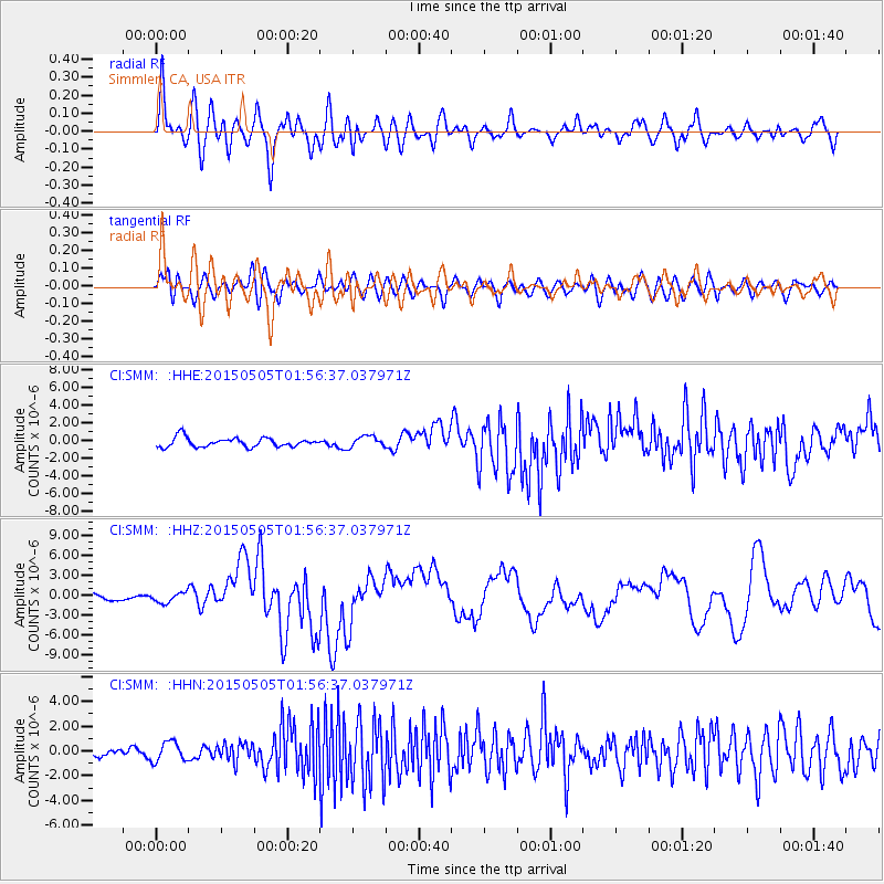
Signal To Noise
| Channel | StoN | STA | LTA |
| CI:SMM: :HHZ:20150505T01:56:37.037971Z | 1.450247 | 7.602909E-7 | 5.2424923E-7 |
| CI:SMM: :HHN:20150505T01:56:37.037971Z | 1.7607292 | 7.8521794E-7 | 4.4596177E-7 |
| CI:SMM: :HHE:20150505T01:56:37.037971Z | 1.2794921 | 6.864168E-7 | 5.3647597E-7 |
| Arrivals |
| Ps | 5.1 SECOND |
| PpPs | 19 SECOND |
| PsPs/PpSs | 24 SECOND |


