You are here: Home > Network List > CN - Canadian National Seismograph Network Stations List
> Station INK INUVIK, NT > Earthquake Result Viewer
INK INUVIK, NT - Earthquake Result Viewer
| Earthquake location: |
New Britain Region, P.N.G. |
| Earthquake latitude/longitude: |
-5.5/151.9 |
| Earthquake time(UTC): |
2015/05/05 (125) 01:44:07 GMT |
| Earthquake Depth: |
63 km |
| Earthquake Magnitude: |
7.4 MWW, 7.5 MI |
| Earthquake Catalog/Contributor: |
NEIC PDE/NEIC COMCAT |
|
| Network: |
CN Canadian National Seismograph Network |
| Station: |
INK INUVIK, NT |
| Lat/Lon: |
68.31 N/133.53 W |
| Elevation: |
44 m |
|
| Distance: |
89.4 deg |
| Az: |
21.001 deg |
| Baz: |
253.652 deg |
| Ray Param: |
0.04175084 |
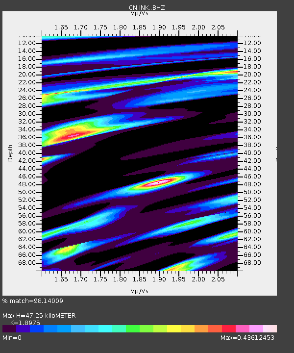
| Estimated Moho Depth: |
47.25 km |
| Estimated Crust Vp/Vs: |
1.90 |
| Assumed Crust Vp: |
6.171 km/s |
| Estimated Crust Vs: |
3.252 km/s |
| Estimated Crust Poisson's Ratio: |
0.31 |
|
| Radial Match: |
98.14009 % |
| Radial Bump: |
311 |
| Transverse Match: |
86.80421 % |
| Transverse Bump: |
400 |
| SOD ConfigId: |
7422571 |
| Insert Time: |
2019-04-18 16:00:13.625 +0000 |
| GWidth: |
2.5 |
| Max Bumps: |
400 |
| Tol: |
0.001 |
|
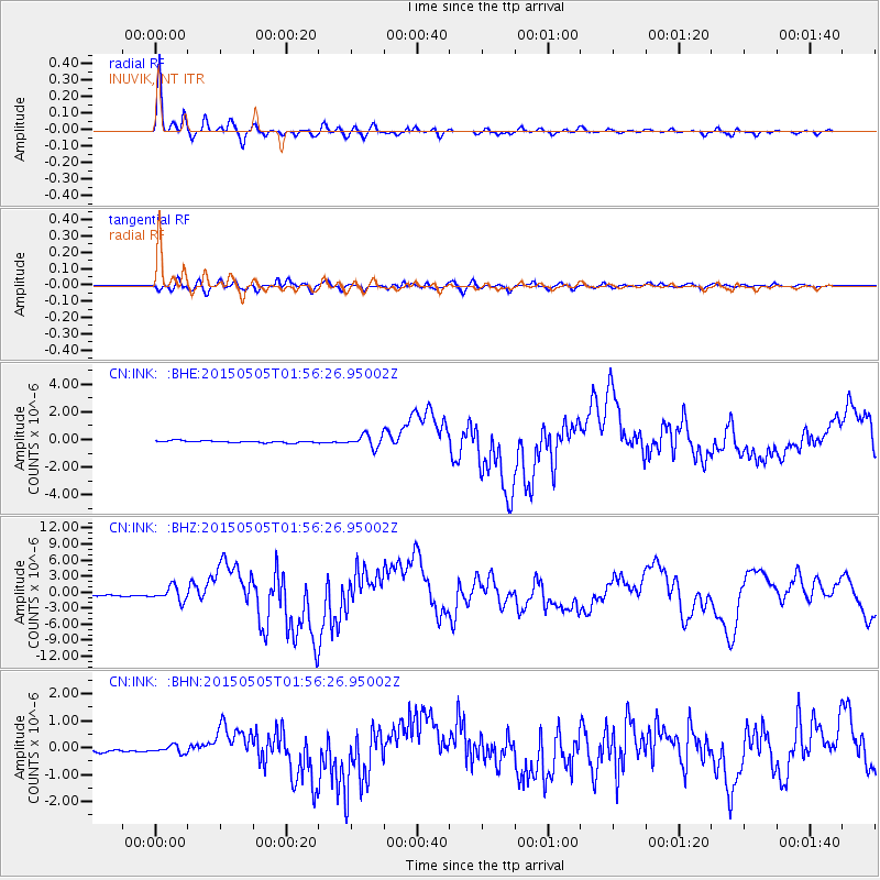
Signal To Noise
| Channel | StoN | STA | LTA |
| CN:INK: :BHZ:20150505T01:56:26.95002Z | 11.139204 | 1.3102482E-6 | 1.17624936E-7 |
| CN:INK: :BHN:20150505T01:56:26.95002Z | 1.9066938 | 1.401844E-7 | 7.352224E-8 |
| CN:INK: :BHE:20150505T01:56:26.95002Z | 5.7673445 | 4.1884405E-7 | 7.262338E-8 |
| Arrivals |
| Ps | 7.0 SECOND |
| PpPs | 22 SECOND |
| PsPs/PpSs | 29 SECOND |


