You are here: Home > Network List > JP - Japan Meteorological Agency Seismic Network Stations List
> Station JMZ Minamidaitojima Island > Earthquake Result Viewer
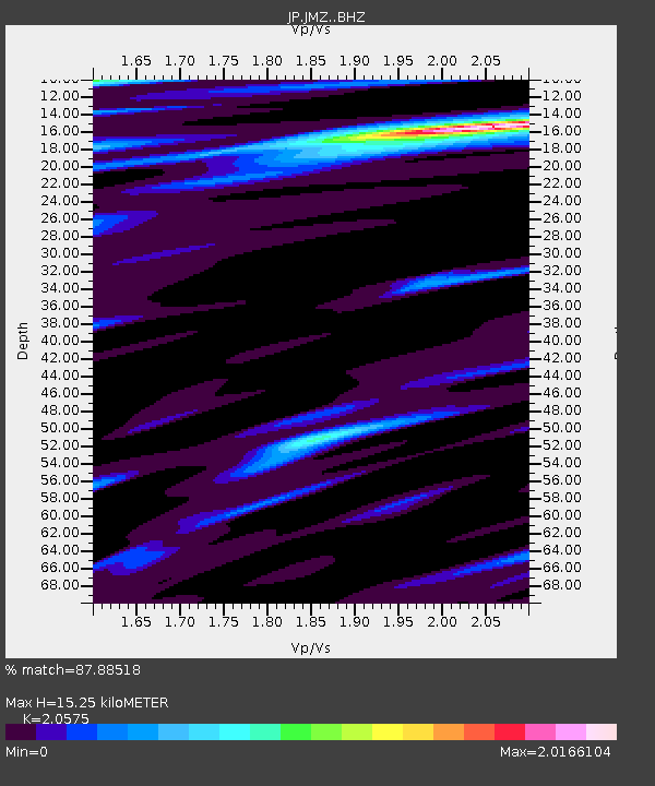
JMZ Minamidaitojima Island - Earthquake Result Viewer
| Earthquake location: |
New Britain Region, P.N.G. |
| Earthquake latitude/longitude: |
-5.5/151.9 |
| Earthquake time(UTC): |
2015/05/05 (125) 01:44:07 GMT |
| Earthquake Depth: |
63 km |
| Earthquake Magnitude: |
7.4 MWW, 7.5 MI |
| Earthquake Catalog/Contributor: |
NEIC PDE/NEIC COMCAT |
|
| Network: |
JP Japan Meteorological Agency Seismic Network |
| Station: |
JMZ Minamidaitojima Island |
| Lat/Lon: |
25.82 N/131.22 E |
| Elevation: |
50 m |
|
| Distance: |
37.1 deg |
| Az: |
328.095 deg |
| Baz: |
144.288 deg |
| Ray Param: |
0.076169714 |
| Estimated Moho Depth: |
15.25 km |
| Estimated Crust Vp/Vs: |
2.06 |
| Assumed Crust Vp: |
4.802 km/s |
| Estimated Crust Vs: |
2.334 km/s |
| Estimated Crust Poisson's Ratio: |
0.35 |
|
| Radial Match: |
87.88518 % |
| Radial Bump: |
249 |
| Transverse Match: |
59.37164 % |
| Transverse Bump: |
400 |
| SOD ConfigId: |
7422571 |
| Insert Time: |
2019-04-18 16:01:01.264 +0000 |
| GWidth: |
2.5 |
| Max Bumps: |
400 |
| Tol: |
0.001 |
|

Signal To Noise
| Channel | StoN | STA | LTA |
| JP:JMZ: :BHZ:20150505T01:50:40.900001Z | 3.7520945 | 2.0898706E-6 | 5.5698774E-7 |
| JP:JMZ: :BHN:20150505T01:50:40.900001Z | 1.2905941 | 1.2262805E-6 | 9.5016736E-7 |
| JP:JMZ: :BHE:20150505T01:50:40.900001Z | 1.4787452 | 1.1794288E-6 | 7.975876E-7 |
| Arrivals |
| Ps | 3.5 SECOND |
| PpPs | 9.4 SECOND |
| PsPs/PpSs | 13 SECOND |


