You are here: Home > Network List > KN - Kyrgyz Seismic Telemetry Network Stations List
> Station ULHL - > Earthquake Result Viewer
ULHL - - Earthquake Result Viewer

| Earthquake location: |
New Britain Region, P.N.G. |
| Earthquake latitude/longitude: |
-5.5/151.9 |
| Earthquake time(UTC): |
2015/05/05 (125) 01:44:07 GMT |
| Earthquake Depth: |
63 km |
| Earthquake Magnitude: |
7.4 MWW, 7.5 MI |
| Earthquake Catalog/Contributor: |
NEIC PDE/NEIC COMCAT |
|
| Network: |
KN Kyrgyz Seismic Telemetry Network |
| Station: |
ULHL - |
| Lat/Lon: |
42.25 N/76.24 E |
| Elevation: |
2040 m |
|
| Distance: |
83.2 deg |
| Az: |
313.566 deg |
| Baz: |
103.734 deg |
| Ray Param: |
0.04626407 |
| Estimated Moho Depth: |
60.5 km |
| Estimated Crust Vp/Vs: |
1.76 |
| Assumed Crust Vp: |
6.306 km/s |
| Estimated Crust Vs: |
3.578 km/s |
| Estimated Crust Poisson's Ratio: |
0.26 |
|
| Radial Match: |
98.223404 % |
| Radial Bump: |
222 |
| Transverse Match: |
94.19603 % |
| Transverse Bump: |
323 |
| SOD ConfigId: |
7422571 |
| Insert Time: |
2019-04-18 16:01:15.368 +0000 |
| GWidth: |
2.5 |
| Max Bumps: |
400 |
| Tol: |
0.001 |
|
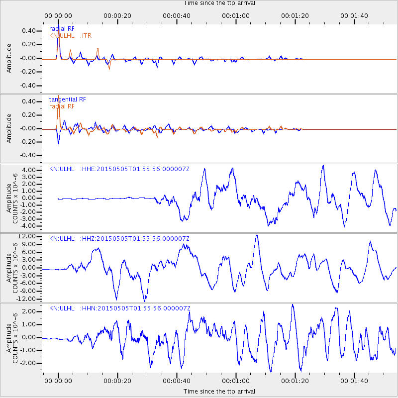
Signal To Noise
| Channel | StoN | STA | LTA |
| KN:ULHL: :HHZ:20150505T01:55:56.000007Z | 5.8454537 | 7.44709E-7 | 1.273997E-7 |
| KN:ULHL: :HHN:20150505T01:55:56.000007Z | 2.9086843 | 8.0741444E-8 | 2.7758752E-8 |
| KN:ULHL: :HHE:20150505T01:55:56.000007Z | 5.2963996 | 3.018926E-7 | 5.699959E-8 |
| Arrivals |
| Ps | 7.5 SECOND |
| PpPs | 26 SECOND |
| PsPs/PpSs | 33 SECOND |


