You are here: Home > Network List > TA - USArray Transportable Network (new EarthScope stations) Stations List
> Station H04D Lebanon, OR, USA > Earthquake Result Viewer
H04D Lebanon, OR, USA - Earthquake Result Viewer

| Earthquake location: |
New Britain Region, P.N.G. |
| Earthquake latitude/longitude: |
-5.5/151.9 |
| Earthquake time(UTC): |
2015/05/05 (125) 01:44:07 GMT |
| Earthquake Depth: |
63 km |
| Earthquake Magnitude: |
7.4 MWW, 7.5 MI |
| Earthquake Catalog/Contributor: |
NEIC PDE/NEIC COMCAT |
|
| Network: |
TA USArray Transportable Network (new EarthScope stations) |
| Station: |
H04D Lebanon, OR, USA |
| Lat/Lon: |
44.52 N/122.74 W |
| Elevation: |
284 m |
|
| Distance: |
90.5 deg |
| Az: |
45.478 deg |
| Baz: |
262.844 deg |
| Ray Param: |
0.041657746 |
| Estimated Moho Depth: |
56.0 km |
| Estimated Crust Vp/Vs: |
1.68 |
| Assumed Crust Vp: |
6.566 km/s |
| Estimated Crust Vs: |
3.903 km/s |
| Estimated Crust Poisson's Ratio: |
0.23 |
|
| Radial Match: |
89.10432 % |
| Radial Bump: |
400 |
| Transverse Match: |
75.52895 % |
| Transverse Bump: |
400 |
| SOD ConfigId: |
7422571 |
| Insert Time: |
2019-04-18 16:02:41.612 +0000 |
| GWidth: |
2.5 |
| Max Bumps: |
400 |
| Tol: |
0.001 |
|
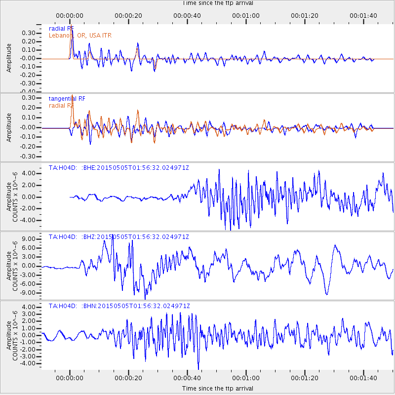
Signal To Noise
| Channel | StoN | STA | LTA |
| TA:H04D: :BHZ:20150505T01:56:32.024971Z | 3.4485643 | 8.0457164E-7 | 2.3330627E-7 |
| TA:H04D: :BHN:20150505T01:56:32.024971Z | 1.1875062 | 4.7607062E-7 | 4.0089947E-7 |
| TA:H04D: :BHE:20150505T01:56:32.024971Z | 0.7015963 | 2.0477866E-7 | 2.9187532E-7 |
| Arrivals |
| Ps | 6.0 SECOND |
| PpPs | 22 SECOND |
| PsPs/PpSs | 28 SECOND |


