You are here: Home > Network List > TA - USArray Transportable Network (new EarthScope stations) Stations List
> Station J05D Fort Rock, OR, USA > Earthquake Result Viewer
J05D Fort Rock, OR, USA - Earthquake Result Viewer
| Earthquake location: |
New Britain Region, P.N.G. |
| Earthquake latitude/longitude: |
-5.5/151.9 |
| Earthquake time(UTC): |
2015/05/05 (125) 01:44:07 GMT |
| Earthquake Depth: |
63 km |
| Earthquake Magnitude: |
7.4 MWW, 7.5 MI |
| Earthquake Catalog/Contributor: |
NEIC PDE/NEIC COMCAT |
|
| Network: |
TA USArray Transportable Network (new EarthScope stations) |
| Station: |
J05D Fort Rock, OR, USA |
| Lat/Lon: |
43.28 N/121.23 W |
| Elevation: |
1541 m |
|
| Distance: |
91.4 deg |
| Az: |
46.834 deg |
| Baz: |
263.859 deg |
| Ray Param: |
0.041586317 |
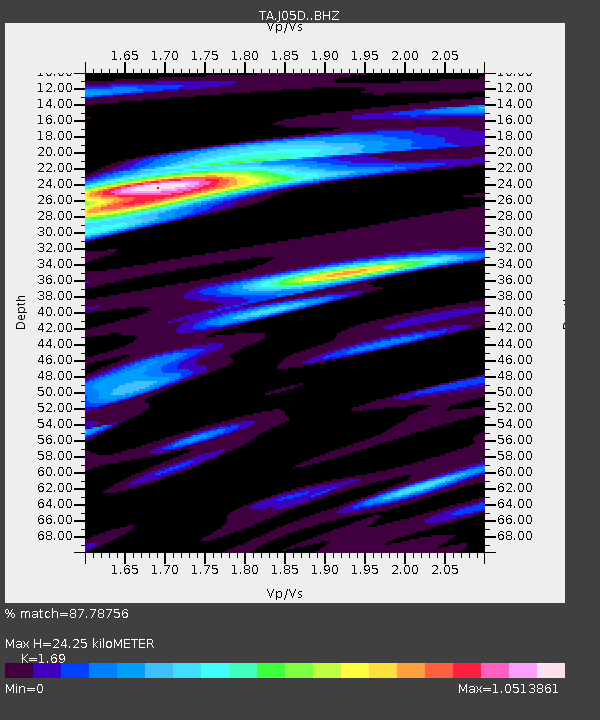
| Estimated Moho Depth: |
24.25 km |
| Estimated Crust Vp/Vs: |
1.69 |
| Assumed Crust Vp: |
6.597 km/s |
| Estimated Crust Vs: |
3.904 km/s |
| Estimated Crust Poisson's Ratio: |
0.23 |
|
| Radial Match: |
87.78756 % |
| Radial Bump: |
400 |
| Transverse Match: |
67.201096 % |
| Transverse Bump: |
400 |
| SOD ConfigId: |
7422571 |
| Insert Time: |
2019-04-18 16:02:51.368 +0000 |
| GWidth: |
2.5 |
| Max Bumps: |
400 |
| Tol: |
0.001 |
|

Signal To Noise
| Channel | StoN | STA | LTA |
| TA:J05D: :BHZ:20150505T01:56:36.349983Z | 2.5928247 | 7.616881E-7 | 2.9376767E-7 |
| TA:J05D: :BHN:20150505T01:56:36.349983Z | 0.77513736 | 2.9773256E-7 | 3.8410295E-7 |
| TA:J05D: :BHE:20150505T01:56:36.349983Z | 1.0429415 | 3.2303268E-7 | 3.0973231E-7 |
| Arrivals |
| Ps | 2.6 SECOND |
| PpPs | 9.7 SECOND |
| PsPs/PpSs | 12 SECOND |


