You are here: Home > Network List > TM - Thai Seismic Monitoring Network Stations List
> Station LOEI LOEI staion > Earthquake Result Viewer
LOEI LOEI staion - Earthquake Result Viewer
| Earthquake location: |
New Britain Region, P.N.G. |
| Earthquake latitude/longitude: |
-5.5/151.9 |
| Earthquake time(UTC): |
2015/05/05 (125) 01:44:07 GMT |
| Earthquake Depth: |
63 km |
| Earthquake Magnitude: |
7.4 MWW, 7.5 MI |
| Earthquake Catalog/Contributor: |
NEIC PDE/NEIC COMCAT |
|
| Network: |
TM Thai Seismic Monitoring Network |
| Station: |
LOEI LOEI staion |
| Lat/Lon: |
17.51 N/101.62 E |
| Elevation: |
305 m |
|
| Distance: |
54.7 deg |
| Az: |
295.855 deg |
| Baz: |
110.156 deg |
| Ray Param: |
0.065137 |
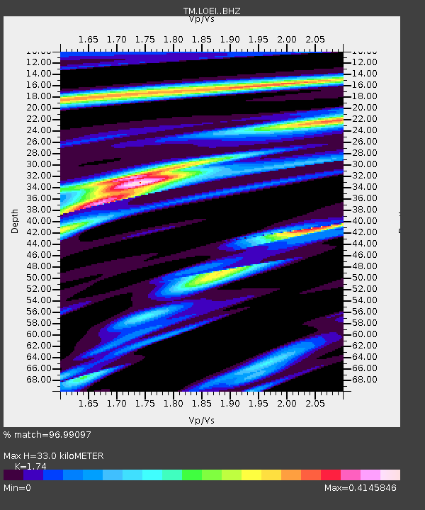
| Estimated Moho Depth: |
33.0 km |
| Estimated Crust Vp/Vs: |
1.74 |
| Assumed Crust Vp: |
6.35 km/s |
| Estimated Crust Vs: |
3.649 km/s |
| Estimated Crust Poisson's Ratio: |
0.25 |
|
| Radial Match: |
96.99097 % |
| Radial Bump: |
224 |
| Transverse Match: |
79.9689 % |
| Transverse Bump: |
367 |
| SOD ConfigId: |
7422571 |
| Insert Time: |
2019-04-18 16:03:09.506 +0000 |
| GWidth: |
2.5 |
| Max Bumps: |
400 |
| Tol: |
0.001 |
|

Signal To Noise
| Channel | StoN | STA | LTA |
| TM:LOEI: :BHZ:20150505T01:52:59.279976Z | 6.1705036 | 1.0110007E-6 | 1.638441E-7 |
| TM:LOEI: :BHN:20150505T01:52:59.279976Z | 0.45341334 | 3.5609006E-7 | 7.853542E-7 |
| TM:LOEI: :BHE:20150505T01:52:59.279976Z | 4.177723 | 4.8485595E-7 | 1.16057464E-7 |
| Arrivals |
| Ps | 4.1 SECOND |
| PpPs | 14 SECOND |
| PsPs/PpSs | 18 SECOND |


