You are here: Home > Network List > TA - USArray Transportable Network (new EarthScope stations) Stations List
> Station W59A Clinton, NC, USA > Earthquake Result Viewer
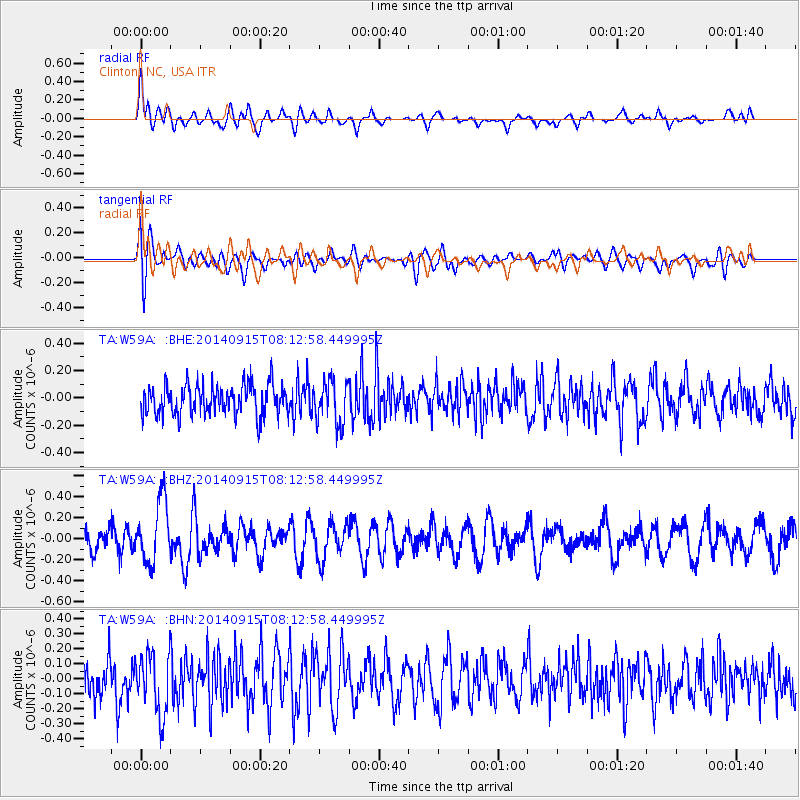
W59A Clinton, NC, USA - Earthquake Result Viewer
*The percent match for this event was below the threshold and hence no stack was calculated.
| Earthquake location: |
Iceland |
| Earthquake latitude/longitude: |
64.6/-17.4 |
| Earthquake time(UTC): |
2014/09/15 (258) 08:05:02 GMT |
| Earthquake Depth: |
10 km |
| Earthquake Magnitude: |
5.5 MWW, 5.5 MWC |
| Earthquake Catalog/Contributor: |
NEIC PDE/NEIC COMCAT |
|
| Network: |
TA USArray Transportable Network (new EarthScope stations) |
| Station: |
W59A Clinton, NC, USA |
| Lat/Lon: |
35.17 N/78.44 W |
| Elevation: |
60 m |
|
| Distance: |
46.5 deg |
| Az: |
261.271 deg |
| Baz: |
31.399 deg |
| Ray Param: |
$rayparam |
*The percent match for this event was below the threshold and hence was not used in the summary stack. |
|
| Radial Match: |
56.340183 % |
| Radial Bump: |
400 |
| Transverse Match: |
57.528122 % |
| Transverse Bump: |
400 |
| SOD ConfigId: |
803114 |
| Insert Time: |
2014-10-23 13:08:43.111 +0000 |
| GWidth: |
2.5 |
| Max Bumps: |
400 |
| Tol: |
0.001 |
|
Signal To Noise
| Channel | StoN | STA | LTA |
| TA:W59A: :BHZ:20140915T08:12:58.449995Z | 3.4613013 | 2.9398666E-7 | 8.4935294E-8 |
| TA:W59A: :BHN:20140915T08:12:58.449995Z | 1.7320079 | 2.059552E-7 | 1.1891124E-7 |
| TA:W59A: :BHE:20140915T08:12:58.449995Z | 1.4175174 | 1.5895675E-7 | 1.1213742E-7 |
| Arrivals |
| Ps | |
| PpPs | |
| PsPs/PpSs | |


