You are here: Home > Network List > XD14 - Illuminating the architecture of the greater Mount St. Helens magmatic systems f Stations List
> Station MD12 "Mount St Helens, WA" > Earthquake Result Viewer
MD12 "Mount St Helens, WA" - Earthquake Result Viewer
| Earthquake location: |
New Britain Region, P.N.G. |
| Earthquake latitude/longitude: |
-5.5/151.9 |
| Earthquake time(UTC): |
2015/05/05 (125) 01:44:07 GMT |
| Earthquake Depth: |
63 km |
| Earthquake Magnitude: |
7.4 MWW, 7.5 MI |
| Earthquake Catalog/Contributor: |
NEIC PDE/NEIC COMCAT |
|
| Network: |
XD Illuminating the architecture of the greater Mount St. Helens magmatic systems f |
| Station: |
MD12 "Mount St Helens, WA" |
| Lat/Lon: |
46.48 N/121.22 W |
| Elevation: |
1496 m |
|
| Distance: |
91.8 deg |
| Az: |
43.66 deg |
| Baz: |
263.959 deg |
| Ray Param: |
0.04153349 |
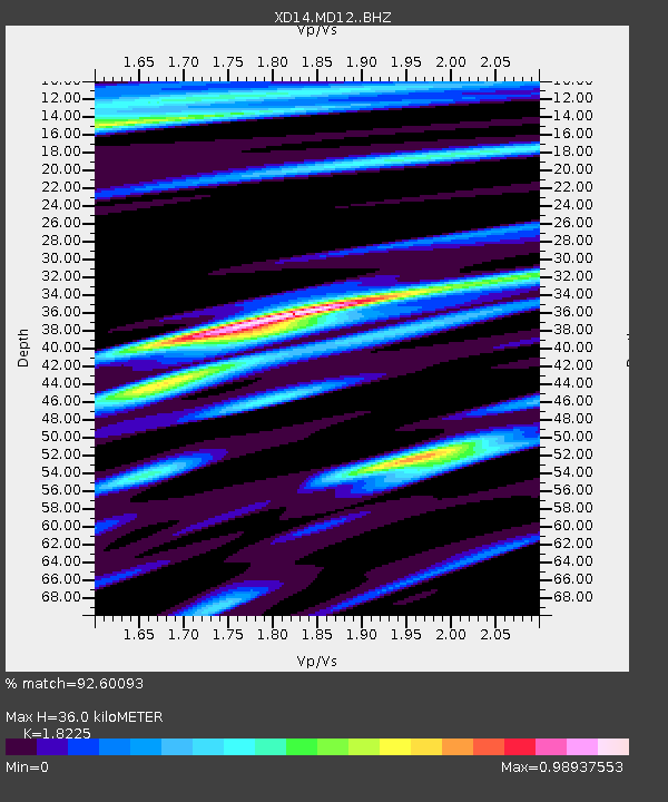
| Estimated Moho Depth: |
36.0 km |
| Estimated Crust Vp/Vs: |
1.82 |
| Assumed Crust Vp: |
6.597 km/s |
| Estimated Crust Vs: |
3.62 km/s |
| Estimated Crust Poisson's Ratio: |
0.28 |
|
| Radial Match: |
92.60093 % |
| Radial Bump: |
400 |
| Transverse Match: |
87.61076 % |
| Transverse Bump: |
400 |
| SOD ConfigId: |
7422571 |
| Insert Time: |
2019-04-18 16:04:14.480 +0000 |
| GWidth: |
2.5 |
| Max Bumps: |
400 |
| Tol: |
0.001 |
|

Signal To Noise
| Channel | StoN | STA | LTA |
| XD:MD12: :BHZ:20150505T01:56:37.964973Z | 4.133677 | 7.189405E-7 | 1.7392274E-7 |
| XD:MD12: :BHN:20150505T01:56:37.964973Z | 1.5733267 | 2.3114958E-7 | 1.4691773E-7 |
| XD:MD12: :BHE:20150505T01:56:37.964973Z | 1.7884238 | 3.0273432E-7 | 1.6927437E-7 |
| Arrivals |
| Ps | 4.6 SECOND |
| PpPs | 15 SECOND |
| PsPs/PpSs | 20 SECOND |


