You are here: Home > Network List > XD14 - Illuminating the architecture of the greater Mount St. Helens magmatic systems f Stations List
> Station MG07 "Mount St Helens, WA" > Earthquake Result Viewer
MG07 "Mount St Helens, WA" - Earthquake Result Viewer
| Earthquake location: |
New Britain Region, P.N.G. |
| Earthquake latitude/longitude: |
-5.5/151.9 |
| Earthquake time(UTC): |
2015/05/05 (125) 01:44:07 GMT |
| Earthquake Depth: |
63 km |
| Earthquake Magnitude: |
7.4 MWW, 7.5 MI |
| Earthquake Catalog/Contributor: |
NEIC PDE/NEIC COMCAT |
|
| Network: |
XD Illuminating the architecture of the greater Mount St. Helens magmatic systems f |
| Station: |
MG07 "Mount St Helens, WA" |
| Lat/Lon: |
46.35 N/122.03 W |
| Elevation: |
1457 m |
|
| Distance: |
91.2 deg |
| Az: |
43.721 deg |
| Baz: |
263.372 deg |
| Ray Param: |
0.041606866 |
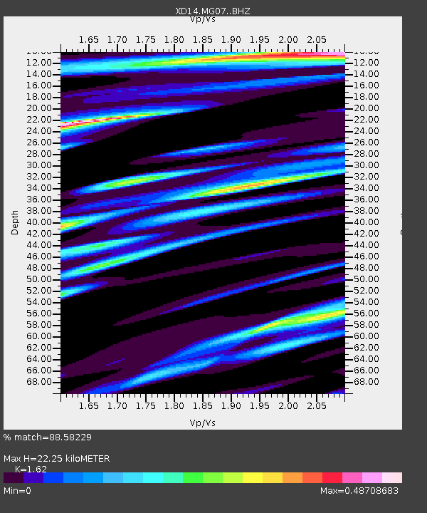
| Estimated Moho Depth: |
22.25 km |
| Estimated Crust Vp/Vs: |
1.62 |
| Assumed Crust Vp: |
6.566 km/s |
| Estimated Crust Vs: |
4.053 km/s |
| Estimated Crust Poisson's Ratio: |
0.19 |
|
| Radial Match: |
88.58229 % |
| Radial Bump: |
400 |
| Transverse Match: |
74.29574 % |
| Transverse Bump: |
400 |
| SOD ConfigId: |
7422571 |
| Insert Time: |
2019-04-18 16:04:25.691 +0000 |
| GWidth: |
2.5 |
| Max Bumps: |
400 |
| Tol: |
0.001 |
|

Signal To Noise
| Channel | StoN | STA | LTA |
| XD:MG07: :BHZ:20150505T01:56:35.31501Z | 3.066351 | 7.141384E-7 | 2.328952E-7 |
| XD:MG07: :BHN:20150505T01:56:35.31501Z | 1.8221786 | 4.05861E-7 | 2.2273393E-7 |
| XD:MG07: :BHE:20150505T01:56:35.31501Z | 0.92619264 | 2.1127487E-7 | 2.2811115E-7 |
| Arrivals |
| Ps | 2.2 SECOND |
| PpPs | 8.7 SECOND |
| PsPs/PpSs | 11 SECOND |


