You are here: Home > Network List > XD14 - Illuminating the architecture of the greater Mount St. Helens magmatic systems f Stations List
> Station MH03 "Mount St Helens, WA" > Earthquake Result Viewer
MH03 "Mount St Helens, WA" - Earthquake Result Viewer
| Earthquake location: |
New Britain Region, P.N.G. |
| Earthquake latitude/longitude: |
-5.5/151.9 |
| Earthquake time(UTC): |
2015/05/05 (125) 01:44:07 GMT |
| Earthquake Depth: |
63 km |
| Earthquake Magnitude: |
7.4 MWW, 7.5 MI |
| Earthquake Catalog/Contributor: |
NEIC PDE/NEIC COMCAT |
|
| Network: |
XD Illuminating the architecture of the greater Mount St. Helens magmatic systems f |
| Station: |
MH03 "Mount St Helens, WA" |
| Lat/Lon: |
46.27 N/122.59 W |
| Elevation: |
373 m |
|
| Distance: |
90.8 deg |
| Az: |
43.759 deg |
| Baz: |
262.965 deg |
| Ray Param: |
0.041635215 |
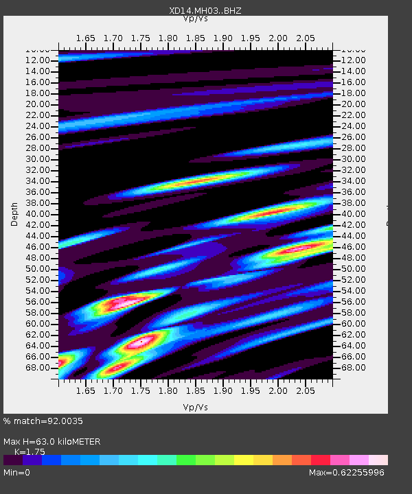
| Estimated Moho Depth: |
63.0 km |
| Estimated Crust Vp/Vs: |
1.75 |
| Assumed Crust Vp: |
6.566 km/s |
| Estimated Crust Vs: |
3.752 km/s |
| Estimated Crust Poisson's Ratio: |
0.26 |
|
| Radial Match: |
92.0035 % |
| Radial Bump: |
391 |
| Transverse Match: |
70.935875 % |
| Transverse Bump: |
400 |
| SOD ConfigId: |
7422571 |
| Insert Time: |
2019-04-18 16:04:29.846 +0000 |
| GWidth: |
2.5 |
| Max Bumps: |
400 |
| Tol: |
0.001 |
|

Signal To Noise
| Channel | StoN | STA | LTA |
| XD:MH03: :BHZ:20150505T01:56:33.484993Z | 3.7726178 | 5.8360666E-7 | 1.5469541E-7 |
| XD:MH03: :BHN:20150505T01:56:33.484993Z | 1.7197778 | 1.5402999E-7 | 8.956388E-8 |
| XD:MH03: :BHE:20150505T01:56:33.484993Z | 3.2308316 | 4.0779253E-7 | 1.2621906E-7 |
| Arrivals |
| Ps | 7.4 SECOND |
| PpPs | 26 SECOND |
| PsPs/PpSs | 33 SECOND |


