You are here: Home > Network List > XD14 - Illuminating the architecture of the greater Mount St. Helens magmatic systems f Stations List
> Station MP03 "Mount St Helens, WA" > Earthquake Result Viewer
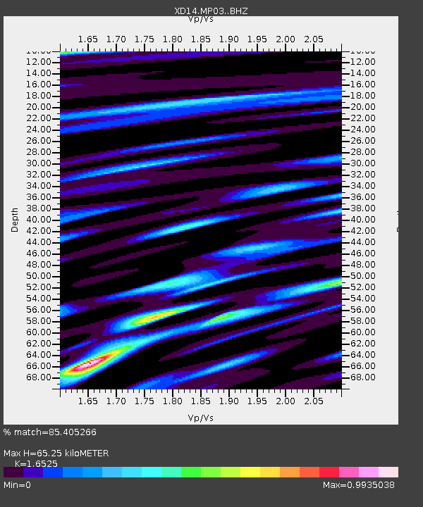
MP03 "Mount St Helens, WA" - Earthquake Result Viewer
| Earthquake location: |
New Britain Region, P.N.G. |
| Earthquake latitude/longitude: |
-5.5/151.9 |
| Earthquake time(UTC): |
2015/05/05 (125) 01:44:07 GMT |
| Earthquake Depth: |
63 km |
| Earthquake Magnitude: |
7.4 MWW, 7.5 MI |
| Earthquake Catalog/Contributor: |
NEIC PDE/NEIC COMCAT |
|
| Network: |
XD Illuminating the architecture of the greater Mount St. Helens magmatic systems f |
| Station: |
MP03 "Mount St Helens, WA" |
| Lat/Lon: |
45.83 N/122.49 W |
| Elevation: |
126 m |
|
| Distance: |
90.8 deg |
| Az: |
44.207 deg |
| Baz: |
263.03 deg |
| Ray Param: |
0.04163415 |
| Estimated Moho Depth: |
65.25 km |
| Estimated Crust Vp/Vs: |
1.65 |
| Assumed Crust Vp: |
6.566 km/s |
| Estimated Crust Vs: |
3.973 km/s |
| Estimated Crust Poisson's Ratio: |
0.21 |
|
| Radial Match: |
85.405266 % |
| Radial Bump: |
400 |
| Transverse Match: |
74.22342 % |
| Transverse Bump: |
400 |
| SOD ConfigId: |
7422571 |
| Insert Time: |
2019-04-18 16:04:59.562 +0000 |
| GWidth: |
2.5 |
| Max Bumps: |
400 |
| Tol: |
0.001 |
|

Signal To Noise
| Channel | StoN | STA | LTA |
| XD:MP03: :BHZ:20150505T01:56:33.560005Z | 3.4494154 | 7.4387276E-7 | 2.1565182E-7 |
| XD:MP03: :BHN:20150505T01:56:33.560005Z | 2.0172343 | 3.597621E-7 | 1.7834422E-7 |
| XD:MP03: :BHE:20150505T01:56:33.560005Z | 0.87660414 | 2.5648254E-7 | 2.9258652E-7 |
| Arrivals |
| Ps | 6.6 SECOND |
| PpPs | 26 SECOND |
| PsPs/PpSs | 32 SECOND |


