You are here: Home > Network List > XD14 - Illuminating the architecture of the greater Mount St. Helens magmatic systems f Stations List
> Station MP10 "Mount St Helens, WA" > Earthquake Result Viewer
MP10 "Mount St Helens, WA" - Earthquake Result Viewer
| Earthquake location: |
New Britain Region, P.N.G. |
| Earthquake latitude/longitude: |
-5.5/151.9 |
| Earthquake time(UTC): |
2015/05/05 (125) 01:44:07 GMT |
| Earthquake Depth: |
63 km |
| Earthquake Magnitude: |
7.4 MWW, 7.5 MI |
| Earthquake Catalog/Contributor: |
NEIC PDE/NEIC COMCAT |
|
| Network: |
XD Illuminating the architecture of the greater Mount St. Helens magmatic systems f |
| Station: |
MP10 "Mount St Helens, WA" |
| Lat/Lon: |
45.90 N/121.80 W |
| Elevation: |
1130 m |
|
| Distance: |
91.3 deg |
| Az: |
44.191 deg |
| Baz: |
263.527 deg |
| Ray Param: |
0.041599218 |
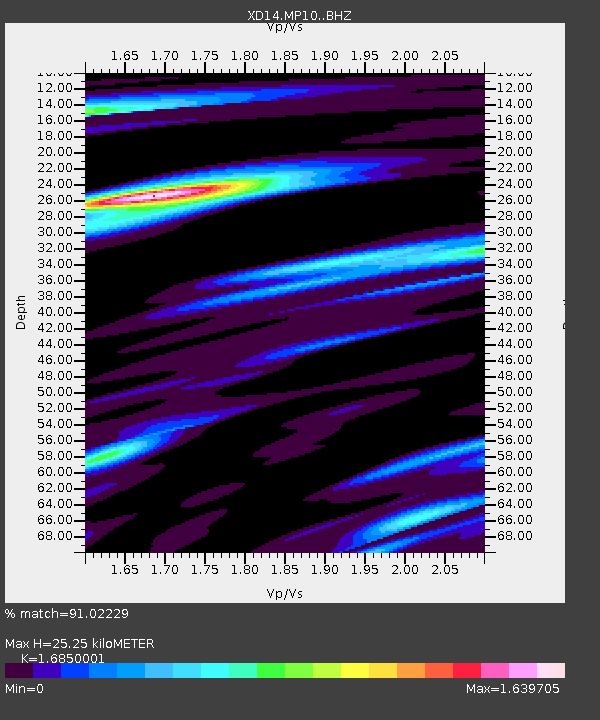
| Estimated Moho Depth: |
25.25 km |
| Estimated Crust Vp/Vs: |
1.69 |
| Assumed Crust Vp: |
6.597 km/s |
| Estimated Crust Vs: |
3.915 km/s |
| Estimated Crust Poisson's Ratio: |
0.23 |
|
| Radial Match: |
91.02229 % |
| Radial Bump: |
400 |
| Transverse Match: |
76.15144 % |
| Transverse Bump: |
400 |
| SOD ConfigId: |
7422571 |
| Insert Time: |
2019-04-18 16:05:02.745 +0000 |
| GWidth: |
2.5 |
| Max Bumps: |
400 |
| Tol: |
0.001 |
|

Signal To Noise
| Channel | StoN | STA | LTA |
| XD:MP10: :BHZ:20150505T01:56:35.81501Z | 5.436383 | 8.65924E-7 | 1.5928312E-7 |
| XD:MP10: :BHN:20150505T01:56:35.81501Z | 0.94796616 | 1.7084521E-7 | 1.802229E-7 |
| XD:MP10: :BHE:20150505T01:56:35.81501Z | 1.0739918 | 2.765468E-7 | 2.5749435E-7 |
| Arrivals |
| Ps | 2.7 SECOND |
| PpPs | 10 SECOND |
| PsPs/PpSs | 13 SECOND |


