You are here: Home > Network List > XD14 - Illuminating the architecture of the greater Mount St. Helens magmatic systems f Stations List
> Station MQ07 "Mount St Helens, WA" > Earthquake Result Viewer
MQ07 "Mount St Helens, WA" - Earthquake Result Viewer
| Earthquake location: |
New Britain Region, P.N.G. |
| Earthquake latitude/longitude: |
-5.5/151.9 |
| Earthquake time(UTC): |
2015/05/05 (125) 01:44:07 GMT |
| Earthquake Depth: |
63 km |
| Earthquake Magnitude: |
7.4 MWW, 7.5 MI |
| Earthquake Catalog/Contributor: |
NEIC PDE/NEIC COMCAT |
|
| Network: |
XD Illuminating the architecture of the greater Mount St. Helens magmatic systems f |
| Station: |
MQ07 "Mount St Helens, WA" |
| Lat/Lon: |
45.81 N/122.11 W |
| Elevation: |
1037 m |
|
| Distance: |
91.1 deg |
| Az: |
44.257 deg |
| Baz: |
263.306 deg |
| Ray Param: |
0.04161513 |
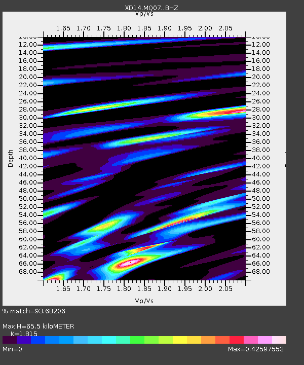
| Estimated Moho Depth: |
65.5 km |
| Estimated Crust Vp/Vs: |
1.82 |
| Assumed Crust Vp: |
6.566 km/s |
| Estimated Crust Vs: |
3.618 km/s |
| Estimated Crust Poisson's Ratio: |
0.28 |
|
| Radial Match: |
93.68206 % |
| Radial Bump: |
338 |
| Transverse Match: |
77.02672 % |
| Transverse Bump: |
400 |
| SOD ConfigId: |
7422571 |
| Insert Time: |
2019-04-18 16:05:02.918 +0000 |
| GWidth: |
2.5 |
| Max Bumps: |
400 |
| Tol: |
0.001 |
|

Signal To Noise
| Channel | StoN | STA | LTA |
| XD:MQ07: :BHZ:20150505T01:56:34.78498Z | 6.095175 | 6.7801585E-7 | 1.1123813E-7 |
| XD:MQ07: :BHN:20150505T01:56:34.78498Z | 1.5809836 | 1.8229687E-7 | 1.1530598E-7 |
| XD:MQ07: :BHE:20150505T01:56:34.78498Z | 3.3639693 | 2.3783797E-7 | 7.070159E-8 |
| Arrivals |
| Ps | 8.3 SECOND |
| PpPs | 27 SECOND |
| PsPs/PpSs | 36 SECOND |


