You are here: Home > Network List > IU - Global Seismograph Network (GSN - IRIS/USGS) Stations List
> Station RSSD Black Hills, South Dakota, USA > Earthquake Result Viewer
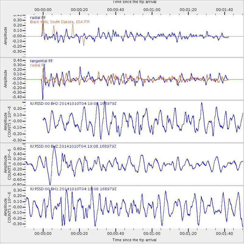
RSSD Black Hills, South Dakota, USA - Earthquake Result Viewer
*The percent match for this event was below the threshold and hence no stack was calculated.
| Earthquake location: |
Southern East Pacific Rise |
| Earthquake latitude/longitude: |
-32.2/-110.8 |
| Earthquake time(UTC): |
2014/10/10 (283) 04:07:51 GMT |
| Earthquake Depth: |
10 km |
| Earthquake Magnitude: |
5.5 MWP |
| Earthquake Catalog/Contributor: |
NEIC PDE/NEIC COMCAT |
|
| Network: |
IU Global Seismograph Network (GSN - IRIS/USGS) |
| Station: |
RSSD Black Hills, South Dakota, USA |
| Lat/Lon: |
44.12 N/104.04 W |
| Elevation: |
2090 m |
|
| Distance: |
76.2 deg |
| Az: |
5.016 deg |
| Baz: |
185.907 deg |
| Ray Param: |
$rayparam |
*The percent match for this event was below the threshold and hence was not used in the summary stack. |
|
| Radial Match: |
53.657925 % |
| Radial Bump: |
400 |
| Transverse Match: |
63.19556 % |
| Transverse Bump: |
400 |
| SOD ConfigId: |
803114 |
| Insert Time: |
2014-10-24 04:31:57.264 +0000 |
| GWidth: |
2.5 |
| Max Bumps: |
400 |
| Tol: |
0.001 |
|
Signal To Noise
| Channel | StoN | STA | LTA |
| IU:RSSD:00:BHZ:20141010T04:19:08.168979Z | 2.275679 | 3.6851972E-7 | 1.6193835E-7 |
| IU:RSSD:00:BH1:20141010T04:19:08.168979Z | 1.1953841 | 1.3836504E-7 | 1.15749444E-7 |
| IU:RSSD:00:BH2:20141010T04:19:08.168979Z | 2.0272284 | 2.0120157E-7 | 9.924958E-8 |
| Arrivals |
| Ps | |
| PpPs | |
| PsPs/PpSs | |


