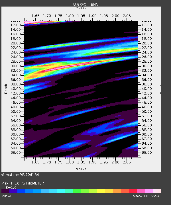
GRFO Grafenberg, Germany - Earthquake Result Viewer

Earthquake location: Afghanistan-Tajikistan Bord Reg.
Earthquake latitude/longitude: 37.1/70.1
Earthquake time(UTC): 1998/05/30 (150) 06:22:28 GMT
Earthquake Depth: 33 km
Earthquake Magnitude: 5.9 MB, 6.9 MS, 6.6 UNKNOWN, 6.5 MW
Earthquake Catalog/Contributor: WHDF/NEIC
Network: IU Global Seismograph Network (GSN - IRIS/USGS)
Station: GRFO Grafenberg, Germany
Lat/Lon: 49.69 N/11.22 E
Elevation: 425 m
Distance: 43.5 deg
Az: 306.161 deg
Baz: 83.665 deg
Ray Param: 0.07242802
Estimated Moho Depth: 10.75 km
Estimated Crust Vp/Vs: 1.60
Assumed Crust Vp: 6.182 km/s
Estimated Crust Vs: 3.864 km/s
Estimated Crust Poisson's Ratio: 0.18
Radial Match: 98.706184 %
Radial Bump: 296
Transverse Match: 88.35923 %
Transverse Bump: 400
SOD ConfigId: 4480
Insert Time: 2010-03-02 02:21:02.337 +0000
GWidth: 2.5
Max Bumps: 400
Tol: 0.001

Signal To Noise

ChannelStoNSTALTA
IU:GRFO: :BHN:19980530T06:29:58.828009Z10.2993094.7754764E-74.6366964E-8
IU:GRFO: :BHE:19980530T06:29:58.828009Z1.07010876.924341E-86.4706896E-8
IU:GRFO: :BHZ:19980530T06:29:58.828009Z4.74568462.86881E-76.045092E-8
Arrivals
Ps1.1 SECOND
PpPs4.2 SECOND
PsPs/PpSs5.3 SECOND