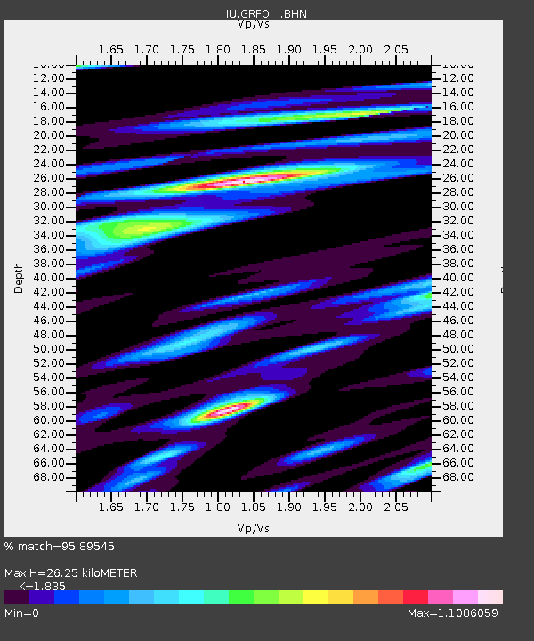
GRFO Grafenberg, Germany - Earthquake Result Viewer

Earthquake location: Near Coast Of Chiapas, Mexico
Earthquake latitude/longitude: 16.0/-93.8
Earthquake time(UTC): 1998/06/07 (158) 23:20:13 GMT
Earthquake Depth: 87 km
Earthquake Magnitude: 5.8 MB, 6.3 UNKNOWN, 6.3 MW
Earthquake Catalog/Contributor: WHDF/NEIC
Network: IU Global Seismograph Network (GSN - IRIS/USGS)
Station: GRFO Grafenberg, Germany
Lat/Lon: 49.69 N/11.22 E
Elevation: 425 m
Distance: 87.4 deg
Az: 38.9 deg
Baz: 291.539 deg
Ray Param: 0.043212045
Estimated Moho Depth: 26.25 km
Estimated Crust Vp/Vs: 1.84
Assumed Crust Vp: 6.182 km/s
Estimated Crust Vs: 3.369 km/s
Estimated Crust Poisson's Ratio: 0.29
Radial Match: 95.89545 %
Radial Bump: 349
Transverse Match: 87.80948 %
Transverse Bump: 400
SOD ConfigId: 4480
Insert Time: 2010-03-02 02:21:09.665 +0000
GWidth: 2.5
Max Bumps: 400
Tol: 0.001

Signal To Noise

ChannelStoNSTALTA
IU:GRFO: :BHN:19980607T23:32:20.066016Z19.2085781.077232E-65.6080776E-8
IU:GRFO: :BHE:19980607T23:32:20.066016Z1.80395851.5942959E-78.837763E-8
IU:GRFO: :BHZ:19980607T23:32:20.066016Z6.17763144.5156258E-77.3096395E-8
Arrivals
Ps3.6 SECOND
PpPs12 SECOND
PsPs/PpSs15 SECOND