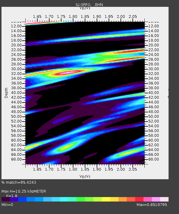
GRFO Grafenberg, Germany - Earthquake Result Viewer

Earthquake location: Off Coast Of Central America
Earthquake latitude/longitude: 11.7/-88.0
Earthquake time(UTC): 1998/08/23 (235) 13:57:15 GMT
Earthquake Depth: 55 km
Earthquake Magnitude: 5.7 MB, 6.3 MS, 6.8 UNKNOWN, 6.7 MW
Earthquake Catalog/Contributor: WHDF/NEIC
Network: IU Global Seismograph Network (GSN - IRIS/USGS)
Station: GRFO Grafenberg, Germany
Lat/Lon: 49.69 N/11.22 E
Elevation: 425 m
Distance: 87.1 deg
Az: 39.924 deg
Baz: 284.515 deg
Ray Param: 0.043461986
Estimated Moho Depth: 10.25 km
Estimated Crust Vp/Vs: 1.60
Assumed Crust Vp: 6.182 km/s
Estimated Crust Vs: 3.864 km/s
Estimated Crust Poisson's Ratio: 0.18
Radial Match: 95.4243 %
Radial Bump: 400
Transverse Match: 83.024704 %
Transverse Bump: 400
SOD ConfigId: 4480
Insert Time: 2010-03-02 02:21:33.806 +0000
GWidth: 2.5
Max Bumps: 400
Tol: 0.001

Signal To Noise

ChannelStoNSTALTA
IU:GRFO: :BHN:19980823T14:09:24.039014Z6.37369065.453532E-78.556317E-8
IU:GRFO: :BHE:19980823T14:09:24.039014Z0.85087699.931202E-81.1671725E-7
IU:GRFO: :BHZ:19980823T14:09:24.039014Z2.1642212.1550241E-79.957505E-8
Arrivals
Ps1.0 SECOND
PpPs4.2 SECOND
PsPs/PpSs5.2 SECOND