You are here: Home > Network List > TA - USArray Transportable Network (new EarthScope stations) Stations List
> Station J01E Myrtle Point, OR, USA > Earthquake Result Viewer
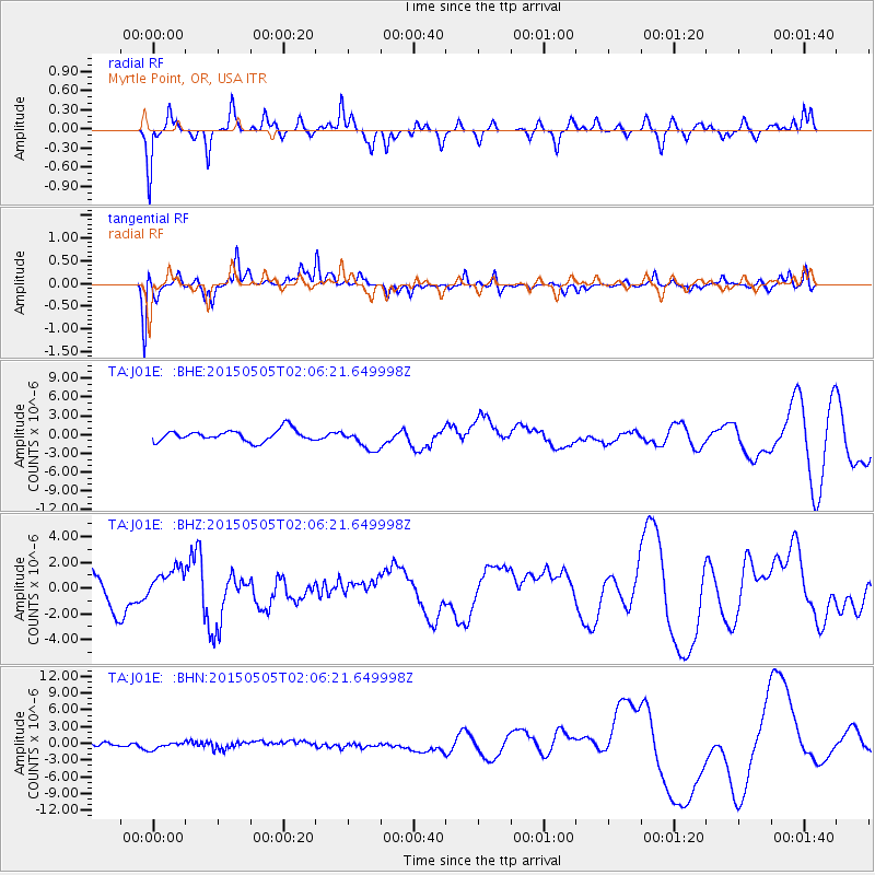
J01E Myrtle Point, OR, USA - Earthquake Result Viewer
*The percent match for this event was below the threshold and hence no stack was calculated.
| Earthquake location: |
New Britain Region, P.N.G. |
| Earthquake latitude/longitude: |
-5.3/152.0 |
| Earthquake time(UTC): |
2015/05/05 (125) 01:54:05 GMT |
| Earthquake Depth: |
64 km |
| Earthquake Magnitude: |
5.9 MB |
| Earthquake Catalog/Contributor: |
NEIC PDE/NEIC COMCAT |
|
| Network: |
TA USArray Transportable Network (new EarthScope stations) |
| Station: |
J01E Myrtle Point, OR, USA |
| Lat/Lon: |
43.16 N/123.93 W |
| Elevation: |
128 m |
|
| Distance: |
89.3 deg |
| Az: |
46.706 deg |
| Baz: |
262.099 deg |
| Ray Param: |
$rayparam |
*The percent match for this event was below the threshold and hence was not used in the summary stack. |
|
| Radial Match: |
59.83509 % |
| Radial Bump: |
307 |
| Transverse Match: |
67.28636 % |
| Transverse Bump: |
382 |
| SOD ConfigId: |
7422571 |
| Insert Time: |
2019-04-18 16:09:20.741 +0000 |
| GWidth: |
2.5 |
| Max Bumps: |
400 |
| Tol: |
0.001 |
|
Signal To Noise
| Channel | StoN | STA | LTA |
| TA:J01E: :BHZ:20150505T02:06:21.649998Z | 0.89694244 | 1.1764754E-6 | 1.3116509E-6 |
| TA:J01E: :BHN:20150505T02:06:21.649998Z | 1.0447673 | 7.2647305E-7 | 6.9534434E-7 |
| TA:J01E: :BHE:20150505T02:06:21.649998Z | 2.1160874 | 1.8514002E-6 | 8.7491674E-7 |
| Arrivals |
| Ps | |
| PpPs | |
| PsPs/PpSs | |


