You are here: Home > Network List > TA - USArray Transportable Network (new EarthScope stations) Stations List
> Station MSTX Muleshoe, TX, USA > Earthquake Result Viewer
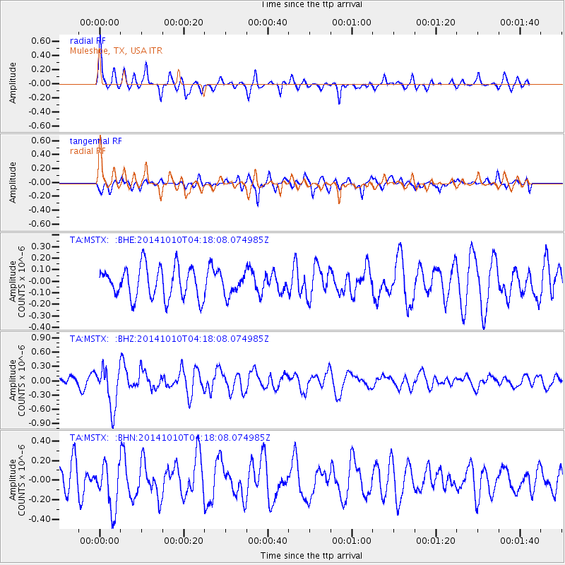
MSTX Muleshoe, TX, USA - Earthquake Result Viewer
*The percent match for this event was below the threshold and hence no stack was calculated.
| Earthquake location: |
Southern East Pacific Rise |
| Earthquake latitude/longitude: |
-32.2/-110.8 |
| Earthquake time(UTC): |
2014/10/10 (283) 04:07:51 GMT |
| Earthquake Depth: |
10 km |
| Earthquake Magnitude: |
5.5 MWP |
| Earthquake Catalog/Contributor: |
NEIC PDE/NEIC COMCAT |
|
| Network: |
TA USArray Transportable Network (new EarthScope stations) |
| Station: |
MSTX Muleshoe, TX, USA |
| Lat/Lon: |
33.97 N/102.77 W |
| Elevation: |
1167 m |
|
| Distance: |
66.3 deg |
| Az: |
7.29 deg |
| Baz: |
187.437 deg |
| Ray Param: |
$rayparam |
*The percent match for this event was below the threshold and hence was not used in the summary stack. |
|
| Radial Match: |
73.84259 % |
| Radial Bump: |
400 |
| Transverse Match: |
54.539734 % |
| Transverse Bump: |
400 |
| SOD ConfigId: |
803114 |
| Insert Time: |
2014-10-24 04:48:44.281 +0000 |
| GWidth: |
2.5 |
| Max Bumps: |
400 |
| Tol: |
0.001 |
|
Signal To Noise
| Channel | StoN | STA | LTA |
| TA:MSTX: :BHZ:20141010T04:18:08.074985Z | 3.756433 | 4.3097714E-7 | 1.1473042E-7 |
| TA:MSTX: :BHN:20141010T04:18:08.074985Z | 1.7015039 | 2.3658158E-7 | 1.3904263E-7 |
| TA:MSTX: :BHE:20141010T04:18:08.074985Z | 0.6591619 | 8.9352056E-8 | 1.3555403E-7 |
| Arrivals |
| Ps | |
| PpPs | |
| PsPs/PpSs | |


