You are here: Home > Network List > TA - USArray Transportable Network (new EarthScope stations) Stations List
> Station N52A McGinn's Farm, Dalton, OH, USA > Earthquake Result Viewer
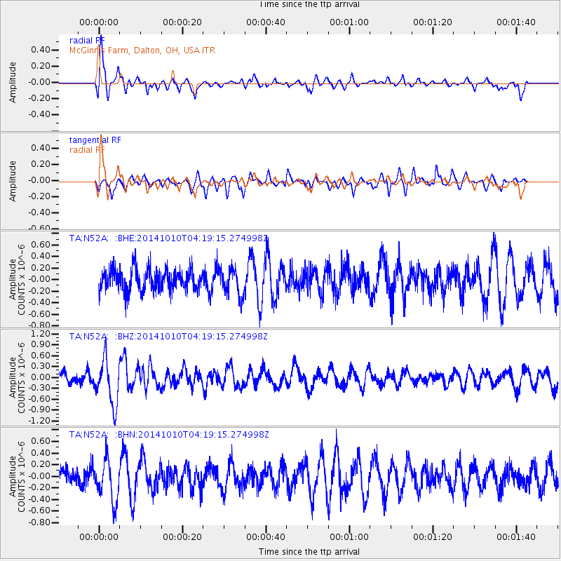
N52A McGinn's Farm, Dalton, OH, USA - Earthquake Result Viewer
*The percent match for this event was below the threshold and hence no stack was calculated.
| Earthquake location: |
Southern East Pacific Rise |
| Earthquake latitude/longitude: |
-32.2/-110.8 |
| Earthquake time(UTC): |
2014/10/10 (283) 04:07:51 GMT |
| Earthquake Depth: |
10 km |
| Earthquake Magnitude: |
5.5 MWP |
| Earthquake Catalog/Contributor: |
NEIC PDE/NEIC COMCAT |
|
| Network: |
TA USArray Transportable Network (new EarthScope stations) |
| Station: |
N52A McGinn's Farm, Dalton, OH, USA |
| Lat/Lon: |
40.81 N/81.69 W |
| Elevation: |
331 m |
|
| Distance: |
77.5 deg |
| Az: |
22.233 deg |
| Baz: |
205.0 deg |
| Ray Param: |
$rayparam |
*The percent match for this event was below the threshold and hence was not used in the summary stack. |
|
| Radial Match: |
75.17569 % |
| Radial Bump: |
400 |
| Transverse Match: |
58.435875 % |
| Transverse Bump: |
400 |
| SOD ConfigId: |
803114 |
| Insert Time: |
2014-10-24 04:48:53.358 +0000 |
| GWidth: |
2.5 |
| Max Bumps: |
400 |
| Tol: |
0.001 |
|
Signal To Noise
| Channel | StoN | STA | LTA |
| TA:N52A: :BHZ:20141010T04:19:15.274998Z | 3.2078226 | 6.3382237E-7 | 1.9758649E-7 |
| TA:N52A: :BHN:20141010T04:19:15.274998Z | 1.9367787 | 3.6456754E-7 | 1.8823398E-7 |
| TA:N52A: :BHE:20141010T04:19:15.274998Z | 1.258296 | 2.3262776E-7 | 1.8487522E-7 |
| Arrivals |
| Ps | |
| PpPs | |
| PsPs/PpSs | |


