You are here: Home > Network List > IU - Global Seismograph Network (GSN - IRIS/USGS) Stations List
> Station GRFO Grafenberg, Germany > Earthquake Result Viewer
GRFO Grafenberg, Germany - Earthquake Result Viewer
| Earthquake location: |
Qinghai, China |
| Earthquake latitude/longitude: |
35.9/90.5 |
| Earthquake time(UTC): |
2001/11/14 (318) 09:26:10 GMT |
| Earthquake Depth: |
10 km |
| Earthquake Magnitude: |
6.1 MB, 8.0 MS, 7.8 MW, 7.7 MW |
| Earthquake Catalog/Contributor: |
WHDF/NEIC |
|
| Network: |
IU Global Seismograph Network (GSN - IRIS/USGS) |
| Station: |
GRFO Grafenberg, Germany |
| Lat/Lon: |
49.69 N/11.22 E |
| Elevation: |
425 m |
|
| Distance: |
57.2 deg |
| Az: |
310.585 deg |
| Baz: |
71.604 deg |
| Ray Param: |
0.06365898 |
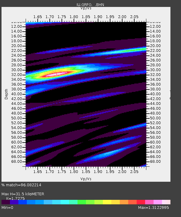
| Estimated Moho Depth: |
31.5 km |
| Estimated Crust Vp/Vs: |
1.73 |
| Assumed Crust Vp: |
6.182 km/s |
| Estimated Crust Vs: |
3.579 km/s |
| Estimated Crust Poisson's Ratio: |
0.25 |
|
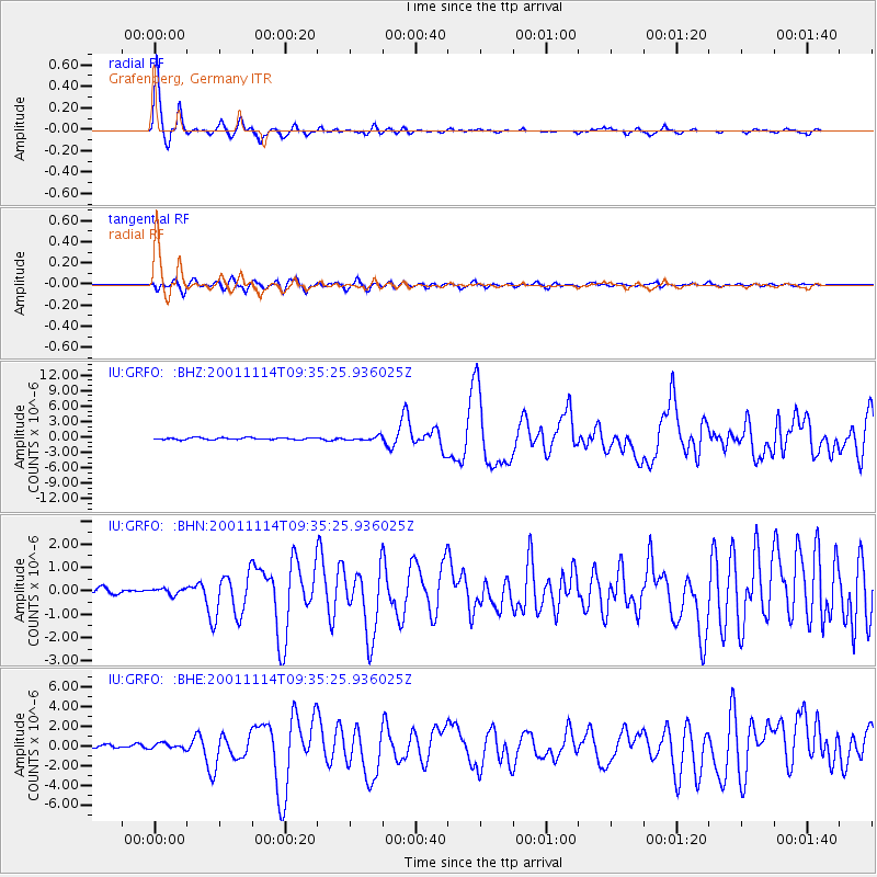
| Radial Match: |
96.082214 % |
| Radial Bump: |
274 |
| Transverse Match: |
84.6533 % |
| Transverse Bump: |
400 |
| SOD ConfigId: |
20082 |
| Insert Time: |
2010-03-02 02:22:09.857 +0000 |
| GWidth: |
2.5 |
| Max Bumps: |
400 |
| Tol: |
0.001 |
|
Signal To Noise
| Channel | StoN | STA | LTA |
| IU:GRFO: :BHN:20011114T09:35:25.936025Z | 0.7088057 | 1.3575207E-7 | 1.9152228E-7 |
| IU:GRFO: :BHE:20011114T09:35:25.936025Z | 1.7466406 | 2.772095E-7 | 1.587101E-7 |
| IU:GRFO: :BHZ:20011114T09:35:25.936025Z | 2.1093342 | 3.8127445E-7 | 1.8075582E-7 |
| Arrivals |
| Ps | 3.9 SECOND |
| PpPs | 13 SECOND |
| PsPs/PpSs | 17 SECOND |


