You are here: Home > Network List > TA - USArray Transportable Network (new EarthScope stations) Stations List
> Station S55A Lewisburg, WV, USA > Earthquake Result Viewer
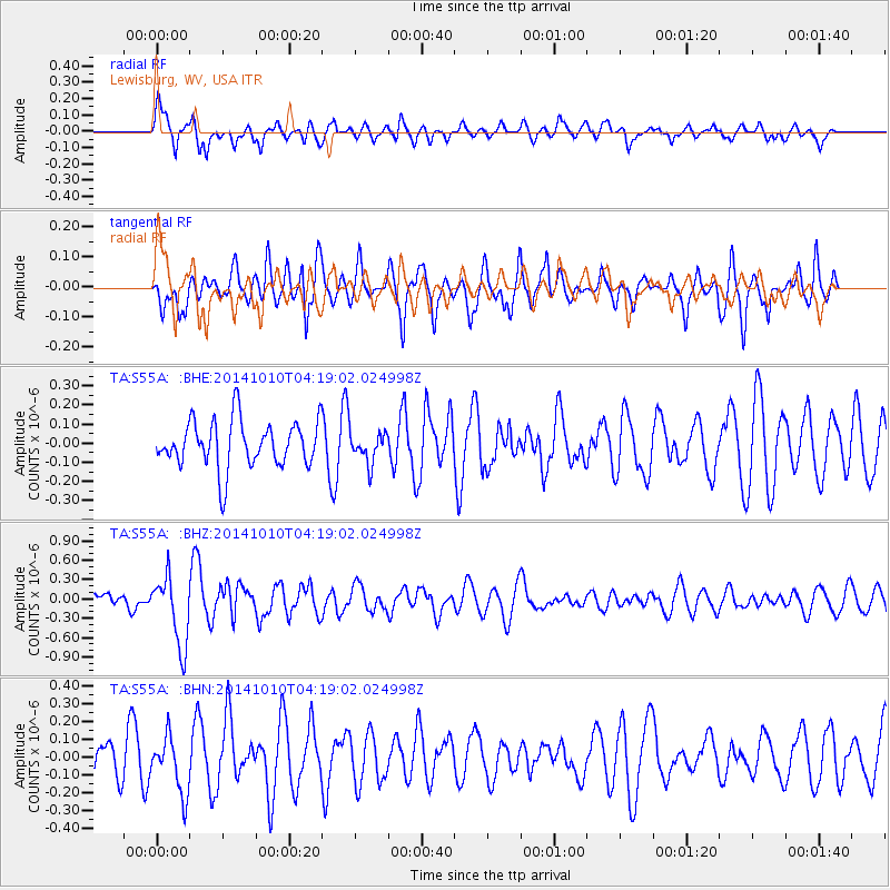
S55A Lewisburg, WV, USA - Earthquake Result Viewer
*The percent match for this event was below the threshold and hence no stack was calculated.
| Earthquake location: |
Southern East Pacific Rise |
| Earthquake latitude/longitude: |
-32.2/-110.8 |
| Earthquake time(UTC): |
2014/10/10 (283) 04:07:51 GMT |
| Earthquake Depth: |
10 km |
| Earthquake Magnitude: |
5.5 MWP |
| Earthquake Catalog/Contributor: |
NEIC PDE/NEIC COMCAT |
|
| Network: |
TA USArray Transportable Network (new EarthScope stations) |
| Station: |
S55A Lewisburg, WV, USA |
| Lat/Lon: |
37.77 N/80.50 W |
| Elevation: |
647 m |
|
| Distance: |
75.1 deg |
| Az: |
24.438 deg |
| Baz: |
206.27 deg |
| Ray Param: |
$rayparam |
*The percent match for this event was below the threshold and hence was not used in the summary stack. |
|
| Radial Match: |
73.08434 % |
| Radial Bump: |
400 |
| Transverse Match: |
56.953 % |
| Transverse Bump: |
400 |
| SOD ConfigId: |
803114 |
| Insert Time: |
2014-10-24 04:51:18.914 +0000 |
| GWidth: |
2.5 |
| Max Bumps: |
400 |
| Tol: |
0.001 |
|
Signal To Noise
| Channel | StoN | STA | LTA |
| TA:S55A: :BHZ:20141010T04:19:02.024998Z | 4.14503 | 5.371704E-7 | 1.2959386E-7 |
| TA:S55A: :BHN:20141010T04:19:02.024998Z | 1.1350349 | 1.5920975E-7 | 1.4026858E-7 |
| TA:S55A: :BHE:20141010T04:19:02.024998Z | 0.6597027 | 8.08073E-8 | 1.2249046E-7 |
| Arrivals |
| Ps | |
| PpPs | |
| PsPs/PpSs | |


