You are here: Home > Network List > TA - USArray Transportable Network (new EarthScope stations) Stations List
> Station S56A Natural Bridge, VA, USA > Earthquake Result Viewer
S56A Natural Bridge, VA, USA - Earthquake Result Viewer
| Earthquake location: |
Southern East Pacific Rise |
| Earthquake latitude/longitude: |
-32.2/-110.8 |
| Earthquake time(UTC): |
2014/10/10 (283) 04:07:51 GMT |
| Earthquake Depth: |
10 km |
| Earthquake Magnitude: |
5.5 MWP |
| Earthquake Catalog/Contributor: |
NEIC PDE/NEIC COMCAT |
|
| Network: |
TA USArray Transportable Network (new EarthScope stations) |
| Station: |
S56A Natural Bridge, VA, USA |
| Lat/Lon: |
37.68 N/79.57 W |
| Elevation: |
449 m |
|
| Distance: |
75.4 deg |
| Az: |
25.167 deg |
| Baz: |
207.025 deg |
| Ray Param: |
0.051705133 |
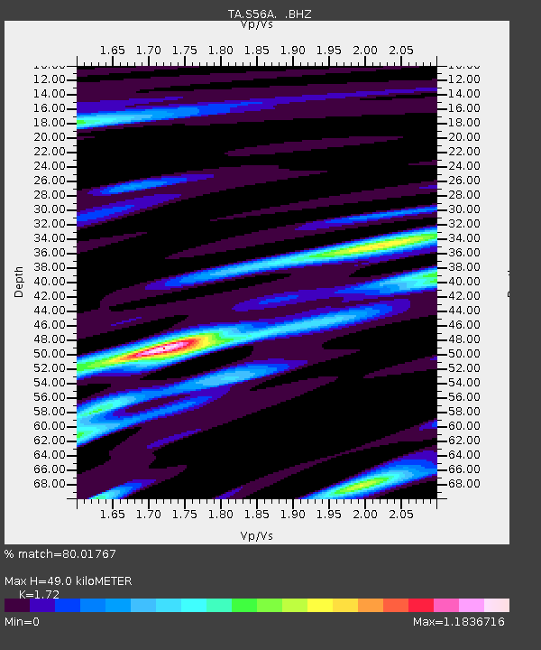
| Estimated Moho Depth: |
49.0 km |
| Estimated Crust Vp/Vs: |
1.72 |
| Assumed Crust Vp: |
6.419 km/s |
| Estimated Crust Vs: |
3.732 km/s |
| Estimated Crust Poisson's Ratio: |
0.24 |
|
| Radial Match: |
80.01767 % |
| Radial Bump: |
400 |
| Transverse Match: |
59.829052 % |
| Transverse Bump: |
400 |
| SOD ConfigId: |
803114 |
| Insert Time: |
2014-10-24 04:51:20.845 +0000 |
| GWidth: |
2.5 |
| Max Bumps: |
400 |
| Tol: |
0.001 |
|
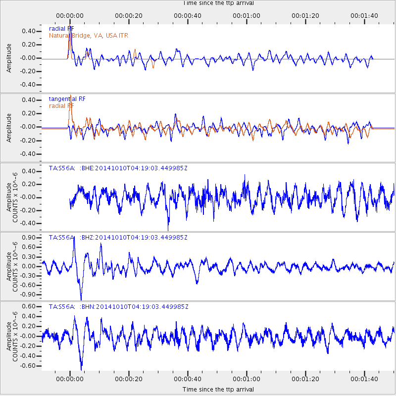
Signal To Noise
| Channel | StoN | STA | LTA |
| TA:S56A: :BHZ:20141010T04:19:03.449985Z | 4.6875105 | 4.6434317E-7 | 9.9059655E-8 |
| TA:S56A: :BHN:20141010T04:19:03.449985Z | 2.7460291 | 2.7565022E-7 | 1.003814E-7 |
| TA:S56A: :BHE:20141010T04:19:03.449985Z | 1.5829983 | 1.6655919E-7 | 1.05217545E-7 |
| Arrivals |
| Ps | 5.7 SECOND |
| PpPs | 20 SECOND |
| PsPs/PpSs | 26 SECOND |


