You are here: Home > Network List > TA - USArray Transportable Network (new EarthScope stations) Stations List
> Station Y57A Sumter, SC, USA > Earthquake Result Viewer
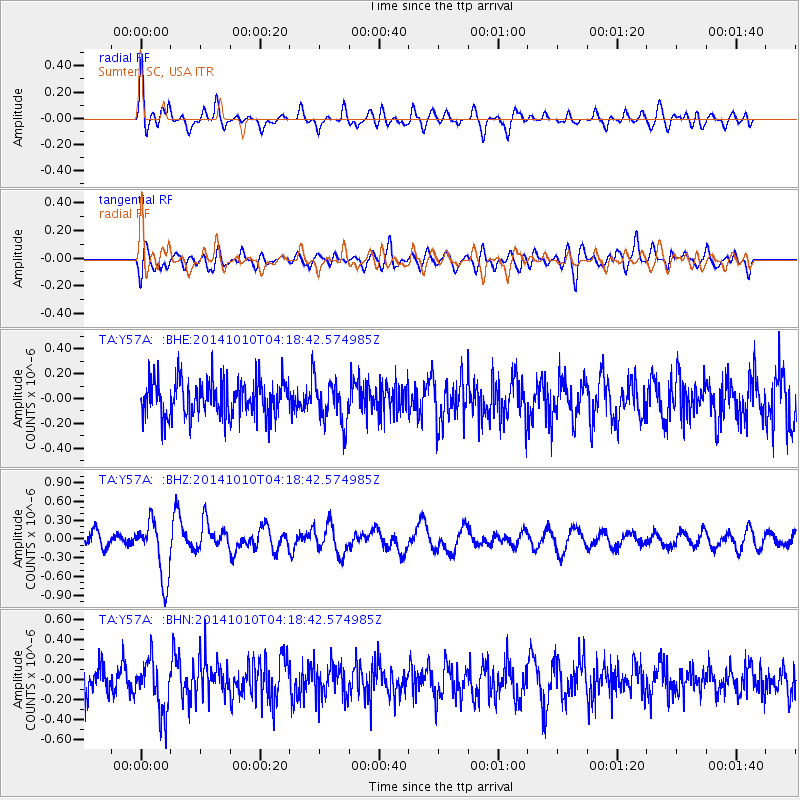
Y57A Sumter, SC, USA - Earthquake Result Viewer
*The percent match for this event was below the threshold and hence no stack was calculated.
| Earthquake location: |
Southern East Pacific Rise |
| Earthquake latitude/longitude: |
-32.2/-110.8 |
| Earthquake time(UTC): |
2014/10/10 (283) 04:07:51 GMT |
| Earthquake Depth: |
10 km |
| Earthquake Magnitude: |
5.5 MWP |
| Earthquake Catalog/Contributor: |
NEIC PDE/NEIC COMCAT |
|
| Network: |
TA USArray Transportable Network (new EarthScope stations) |
| Station: |
Y57A Sumter, SC, USA |
| Lat/Lon: |
34.02 N/80.39 W |
| Elevation: |
56 m |
|
| Distance: |
71.8 deg |
| Az: |
26.269 deg |
| Baz: |
206.855 deg |
| Ray Param: |
$rayparam |
*The percent match for this event was below the threshold and hence was not used in the summary stack. |
|
| Radial Match: |
64.351006 % |
| Radial Bump: |
400 |
| Transverse Match: |
47.628456 % |
| Transverse Bump: |
400 |
| SOD ConfigId: |
803114 |
| Insert Time: |
2014-10-24 04:53:41.592 +0000 |
| GWidth: |
2.5 |
| Max Bumps: |
400 |
| Tol: |
0.001 |
|
Signal To Noise
| Channel | StoN | STA | LTA |
| TA:Y57A: :BHZ:20141010T04:18:42.574985Z | 4.2932153 | 4.682397E-7 | 1.0906504E-7 |
| TA:Y57A: :BHN:20141010T04:18:42.574985Z | 1.8550072 | 2.5332093E-7 | 1.3656062E-7 |
| TA:Y57A: :BHE:20141010T04:18:42.574985Z | 1.1380569 | 1.6818339E-7 | 1.477812E-7 |
| Arrivals |
| Ps | |
| PpPs | |
| PsPs/PpSs | |


