You are here: Home > Network List > UW - Pacific Northwest Regional Seismic Network Stations List
> Station MRBL Marblemount, WA, USA > Earthquake Result Viewer
MRBL Marblemount, WA, USA - Earthquake Result Viewer
*The percent match for this event was below the threshold and hence no stack was calculated.
| Earthquake location: |
Southern East Pacific Rise |
| Earthquake latitude/longitude: |
-32.2/-110.8 |
| Earthquake time(UTC): |
2014/10/10 (283) 04:07:51 GMT |
| Earthquake Depth: |
10 km |
| Earthquake Magnitude: |
5.5 MWP |
| Earthquake Catalog/Contributor: |
NEIC PDE/NEIC COMCAT |
|
| Network: |
UW Pacific Northwest Regional Seismic Network |
| Station: |
MRBL Marblemount, WA, USA |
| Lat/Lon: |
48.52 N/121.48 W |
| Elevation: |
75 m |
|
| Distance: |
80.9 deg |
| Az: |
352.833 deg |
| Baz: |
170.847 deg |
| Ray Param: |
$rayparam |
*The percent match for this event was below the threshold and hence was not used in the summary stack. |
|
| Radial Match: |
59.481842 % |
| Radial Bump: |
400 |
| Transverse Match: |
68.492096 % |
| Transverse Bump: |
400 |
| SOD ConfigId: |
803114 |
| Insert Time: |
2014-10-24 04:57:50.274 +0000 |
| GWidth: |
2.5 |
| Max Bumps: |
400 |
| Tol: |
0.001 |
|
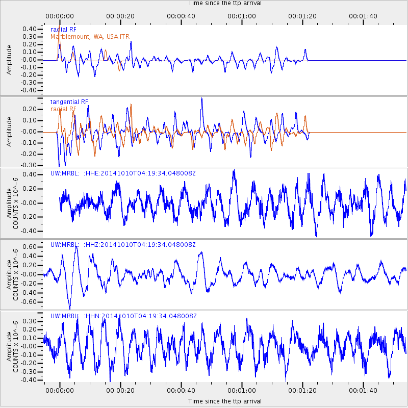
Signal To Noise
| Channel | StoN | STA | LTA |
| UW:MRBL: :HHZ:20141010T04:19:34.048008Z | 2.7206478 | 3.4052684E-7 | 1.2516387E-7 |
| UW:MRBL: :HHN:20141010T04:19:34.048008Z | 1.7040279 | 1.6635191E-7 | 9.762277E-8 |
| UW:MRBL: :HHE:20141010T04:19:34.048008Z | 1.0692565 | 1.2978747E-7 | 1.2138105E-7 |
| Arrivals |
| Ps | |
| PpPs | |
| PsPs/PpSs | |


