You are here: Home > Network List > WY - Yellowstone Wyoming Seismic Network Stations List
> Station YHH Holmes Hill, YNP, WY, USA > Earthquake Result Viewer
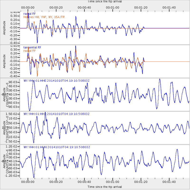
YHH Holmes Hill, YNP, WY, USA - Earthquake Result Viewer
*The percent match for this event was below the threshold and hence no stack was calculated.
| Earthquake location: |
Southern East Pacific Rise |
| Earthquake latitude/longitude: |
-32.2/-110.8 |
| Earthquake time(UTC): |
2014/10/10 (283) 04:07:51 GMT |
| Earthquake Depth: |
10 km |
| Earthquake Magnitude: |
5.5 MWP |
| Earthquake Catalog/Contributor: |
NEIC PDE/NEIC COMCAT |
|
| Network: |
WY Yellowstone Wyoming Seismic Network |
| Station: |
YHH Holmes Hill, YNP, WY, USA |
| Lat/Lon: |
44.79 N/110.85 W |
| Elevation: |
2717 m |
|
| Distance: |
76.6 deg |
| Az: |
359.968 deg |
| Baz: |
179.962 deg |
| Ray Param: |
$rayparam |
*The percent match for this event was below the threshold and hence was not used in the summary stack. |
|
| Radial Match: |
59.054752 % |
| Radial Bump: |
400 |
| Transverse Match: |
56.213165 % |
| Transverse Bump: |
335 |
| SOD ConfigId: |
803114 |
| Insert Time: |
2014-10-24 04:59:55.970 +0000 |
| GWidth: |
2.5 |
| Max Bumps: |
400 |
| Tol: |
0.001 |
|
Signal To Noise
| Channel | StoN | STA | LTA |
| WY:YHH:01:HHZ:20141010T04:19:10.50803Z | 1.9258348 | 7.0108506E-9 | 3.6404215E-9 |
| WY:YHH:01:HHN:20141010T04:19:10.50803Z | 1.5018495 | 6.30387E-9 | 4.197404E-9 |
| WY:YHH:01:HHE:20141010T04:19:10.50803Z | 0.789324 | 3.5099845E-9 | 4.4468234E-9 |
| Arrivals |
| Ps | |
| PpPs | |
| PsPs/PpSs | |


