You are here: Home > Network List > AK - Alaska Regional Network Stations List
> Station PWL Port Wells, AK, USA > Earthquake Result Viewer
PWL Port Wells, AK, USA - Earthquake Result Viewer
| Earthquake location: |
Morocco |
| Earthquake latitude/longitude: |
32.3/-6.2 |
| Earthquake time(UTC): |
2015/05/05 (125) 02:03:18 GMT |
| Earthquake Depth: |
14 km |
| Earthquake Magnitude: |
6.1 ml |
| Earthquake Catalog/Contributor: |
ISC/ISC |
|
| Network: |
AK Alaska Regional Network |
| Station: |
PWL Port Wells, AK, USA |
| Lat/Lon: |
60.86 N/148.33 W |
| Elevation: |
555 m |
|
| Distance: |
82.2 deg |
| Az: |
342.363 deg |
| Baz: |
31.632 deg |
| Ray Param: |
0.047044184 |
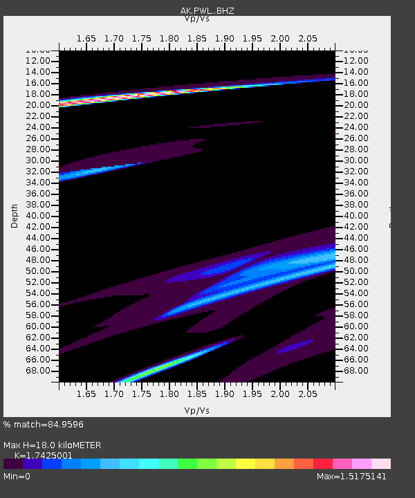
| Estimated Moho Depth: |
18.0 km |
| Estimated Crust Vp/Vs: |
1.74 |
| Assumed Crust Vp: |
6.566 km/s |
| Estimated Crust Vs: |
3.768 km/s |
| Estimated Crust Poisson's Ratio: |
0.25 |
|
| Radial Match: |
84.9596 % |
| Radial Bump: |
269 |
| Transverse Match: |
58.17304 % |
| Transverse Bump: |
400 |
| SOD ConfigId: |
7422571 |
| Insert Time: |
2019-04-18 16:16:08.792 +0000 |
| GWidth: |
2.5 |
| Max Bumps: |
400 |
| Tol: |
0.001 |
|

Signal To Noise
| Channel | StoN | STA | LTA |
| AK:PWL: :BHZ:20150505T02:15:07.868025Z | 2.7968698 | 1.1122672E-5 | 3.976829E-6 |
| AK:PWL: :BHN:20150505T02:15:07.868025Z | 2.6937444 | 7.0926444E-6 | 2.6330058E-6 |
| AK:PWL: :BHE:20150505T02:15:07.868025Z | 2.9641428 | 1.1057499E-5 | 3.7304205E-6 |
| Arrivals |
| Ps | 2.1 SECOND |
| PpPs | 7.3 SECOND |
| PsPs/PpSs | 9.4 SECOND |


