You are here: Home > Network List > CI - Caltech Regional Seismic Network Stations List
> Station CWC CWC, Lone Pine, CA, USA > Earthquake Result Viewer
CWC CWC, Lone Pine, CA, USA - Earthquake Result Viewer
| Earthquake location: |
Fiji Islands Region |
| Earthquake latitude/longitude: |
-21.6/-176.4 |
| Earthquake time(UTC): |
1998/12/27 (361) 00:38:26 GMT |
| Earthquake Depth: |
144 km |
| Earthquake Magnitude: |
6.1 MB, 6.9 UNKNOWN, 6.6 ME |
| Earthquake Catalog/Contributor: |
WHDF/NEIC |
|
| Network: |
CI Caltech Regional Seismic Network |
| Station: |
CWC CWC, Lone Pine, CA, USA |
| Lat/Lon: |
36.44 N/118.08 W |
| Elevation: |
1595 m |
|
| Distance: |
79.8 deg |
| Az: |
44.197 deg |
| Baz: |
233.548 deg |
| Ray Param: |
0.04838927 |
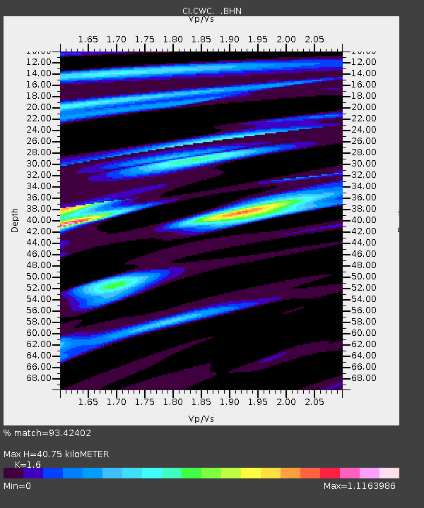
| Estimated Moho Depth: |
40.75 km |
| Estimated Crust Vp/Vs: |
1.60 |
| Assumed Crust Vp: |
6.291 km/s |
| Estimated Crust Vs: |
3.932 km/s |
| Estimated Crust Poisson's Ratio: |
0.18 |
|
| Radial Match: |
93.42402 % |
| Radial Bump: |
400 |
| Transverse Match: |
91.835625 % |
| Transverse Bump: |
400 |
| SOD ConfigId: |
3787 |
| Insert Time: |
2010-02-25 21:19:15.323 +0000 |
| GWidth: |
2.5 |
| Max Bumps: |
400 |
| Tol: |
0.001 |
|

Signal To Noise
| Channel | StoN | STA | LTA |
| CI:CWC: :BHN:19981227T00:49:47.788013Z | 1.668058 | 1.254681E-7 | 7.521807E-8 |
| CI:CWC: :BHE:19981227T00:49:47.788013Z | 1.1727376 | 1.031767E-7 | 8.797936E-8 |
| CI:CWC: :BHZ:19981227T00:49:47.788013Z | 6.635931 | 8.422637E-7 | 1.2692473E-7 |
| Arrivals |
| Ps | 4.0 SECOND |
| PpPs | 16 SECOND |
| PsPs/PpSs | 20 SECOND |


