You are here: Home > Network List > CI - Caltech Regional Seismic Network Stations List
> Station CWC CWC, Lone Pine, CA, USA > Earthquake Result Viewer
CWC CWC, Lone Pine, CA, USA - Earthquake Result Viewer

| Earthquake location: |
Kodiak Island Region, Alaska |
| Earthquake latitude/longitude: |
57.4/-154.4 |
| Earthquake time(UTC): |
1999/12/06 (340) 23:22:55 GMT |
| Earthquake Depth: |
50 km |
| Earthquake Magnitude: |
5.6 MB, 5.5 ML, 5.4 ML |
| Earthquake Catalog/Contributor: |
WHDF/NEIC |
|
| Network: |
CI Caltech Regional Seismic Network |
| Station: |
CWC CWC, Lone Pine, CA, USA |
| Lat/Lon: |
36.44 N/118.08 W |
| Elevation: |
1595 m |
|
| Distance: |
31.9 deg |
| Az: |
115.281 deg |
| Baz: |
322.581 deg |
| Ray Param: |
0.07878508 |
| Estimated Moho Depth: |
36.5 km |
| Estimated Crust Vp/Vs: |
1.73 |
| Assumed Crust Vp: |
6.291 km/s |
| Estimated Crust Vs: |
3.647 km/s |
| Estimated Crust Poisson's Ratio: |
0.25 |
|
| Radial Match: |
94.226906 % |
| Radial Bump: |
400 |
| Transverse Match: |
60.280354 % |
| Transverse Bump: |
400 |
| SOD ConfigId: |
3770 |
| Insert Time: |
2010-02-25 21:19:16.304 +0000 |
| GWidth: |
2.5 |
| Max Bumps: |
400 |
| Tol: |
0.001 |
|
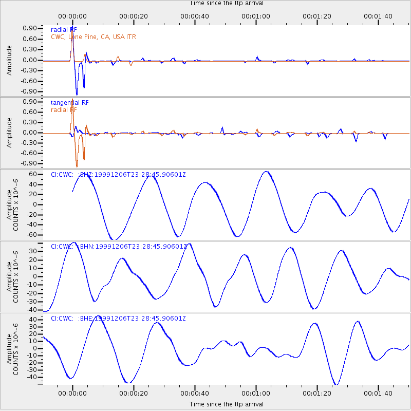
Signal To Noise
| Channel | StoN | STA | LTA |
| CI:CWC: :BHN:19991206T23:28:45.90601Z | 1.2559087 | 3.5469755E-5 | 2.8242304E-5 |
| CI:CWC: :BHE:19991206T23:28:45.90601Z | 1.2430539 | 2.7099815E-5 | 2.1801E-5 |
| CI:CWC: :BHZ:19991206T23:28:45.90601Z | 0.86679614 | 3.9985065E-5 | 4.6129724E-5 |
| Arrivals |
| Ps | 4.5 SECOND |
| PpPs | 15 SECOND |
| PsPs/PpSs | 19 SECOND |


