You are here: Home > Network List > KO - Kandilli Observatory Digital Broadband Seismic Network Stations List
> Station SIRT Sirnak-Turkey > Earthquake Result Viewer
SIRT Sirnak-Turkey - Earthquake Result Viewer
| Earthquake location: |
Off East Coast Of Honshu, Japan |
| Earthquake latitude/longitude: |
41.0/143.2 |
| Earthquake time(UTC): |
2014/10/11 (284) 02:35:46 GMT |
| Earthquake Depth: |
14 km |
| Earthquake Magnitude: |
6.3 MWP |
| Earthquake Catalog/Contributor: |
NEIC PDE/NEIC COMCAT |
|
| Network: |
KO Kandilli Observatory Digital Broadband Seismic Network |
| Station: |
SIRT Sirnak-Turkey |
| Lat/Lon: |
37.50 N/42.44 E |
| Elevation: |
1038 m |
|
| Distance: |
73.5 deg |
| Az: |
305.442 deg |
| Baz: |
50.851 deg |
| Ray Param: |
0.05293507 |
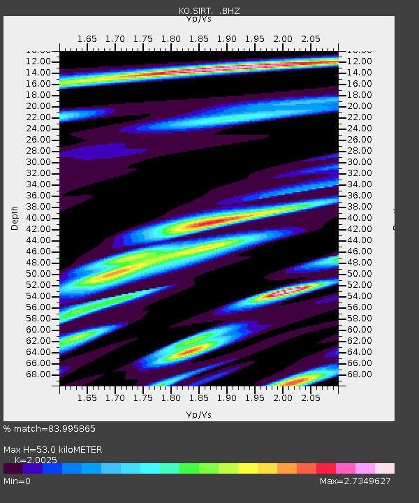
| Estimated Moho Depth: |
53.0 km |
| Estimated Crust Vp/Vs: |
2.00 |
| Assumed Crust Vp: |
6.482 km/s |
| Estimated Crust Vs: |
3.237 km/s |
| Estimated Crust Poisson's Ratio: |
0.33 |
|
| Radial Match: |
83.995865 % |
| Radial Bump: |
400 |
| Transverse Match: |
77.45719 % |
| Transverse Bump: |
400 |
| SOD ConfigId: |
803114 |
| Insert Time: |
2014-10-25 02:50:16.745 +0000 |
| GWidth: |
2.5 |
| Max Bumps: |
400 |
| Tol: |
0.001 |
|

Signal To Noise
| Channel | StoN | STA | LTA |
| KO:SIRT: :BHZ:20141011T02:46:47.259978Z | 41.63802 | 5.5610417E-6 | 1.3355682E-7 |
| KO:SIRT: :BHN:20141011T02:46:47.259978Z | 5.9665203 | 8.041948E-7 | 1.3478456E-7 |
| KO:SIRT: :BHE:20141011T02:46:47.259978Z | 8.663606 | 2.9295727E-6 | 3.3814703E-7 |
| Arrivals |
| Ps | 8.5 SECOND |
| PpPs | 24 SECOND |
| PsPs/PpSs | 32 SECOND |


