You are here: Home > Network List > TA - USArray Transportable Network (new EarthScope stations) Stations List
> Station N62A Caumsett State Park, Huntington, NY, USA > Earthquake Result Viewer
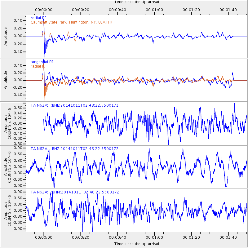
N62A Caumsett State Park, Huntington, NY, USA - Earthquake Result Viewer
*The percent match for this event was below the threshold and hence no stack was calculated.
| Earthquake location: |
Off East Coast Of Honshu, Japan |
| Earthquake latitude/longitude: |
41.0/143.2 |
| Earthquake time(UTC): |
2014/10/11 (284) 02:35:46 GMT |
| Earthquake Depth: |
14 km |
| Earthquake Magnitude: |
6.3 MWP |
| Earthquake Catalog/Contributor: |
NEIC PDE/NEIC COMCAT |
|
| Network: |
TA USArray Transportable Network (new EarthScope stations) |
| Station: |
N62A Caumsett State Park, Huntington, NY, USA |
| Lat/Lon: |
40.93 N/73.47 W |
| Elevation: |
34 m |
|
| Distance: |
91.9 deg |
| Az: |
26.929 deg |
| Baz: |
333.095 deg |
| Ray Param: |
$rayparam |
*The percent match for this event was below the threshold and hence was not used in the summary stack. |
|
| Radial Match: |
64.810745 % |
| Radial Bump: |
400 |
| Transverse Match: |
48.24515 % |
| Transverse Bump: |
400 |
| SOD ConfigId: |
803114 |
| Insert Time: |
2014-10-25 03:00:52.366 +0000 |
| GWidth: |
2.5 |
| Max Bumps: |
400 |
| Tol: |
0.001 |
|
Signal To Noise
| Channel | StoN | STA | LTA |
| TA:N62A: :BHZ:20141011T02:48:22.550017Z | 1.8543316 | 4.1024074E-7 | 2.2123375E-7 |
| TA:N62A: :BHN:20141011T02:48:22.550017Z | 2.230703 | 5.234025E-7 | 2.3463565E-7 |
| TA:N62A: :BHE:20141011T02:48:22.550017Z | 1.0114931 | 2.0057777E-7 | 1.9829871E-7 |
| Arrivals |
| Ps | |
| PpPs | |
| PsPs/PpSs | |


