You are here: Home > Network List > TA - USArray Transportable Network (new EarthScope stations) Stations List
> Station V60A Jim Taylor Road, Stokes, NC, USA > Earthquake Result Viewer
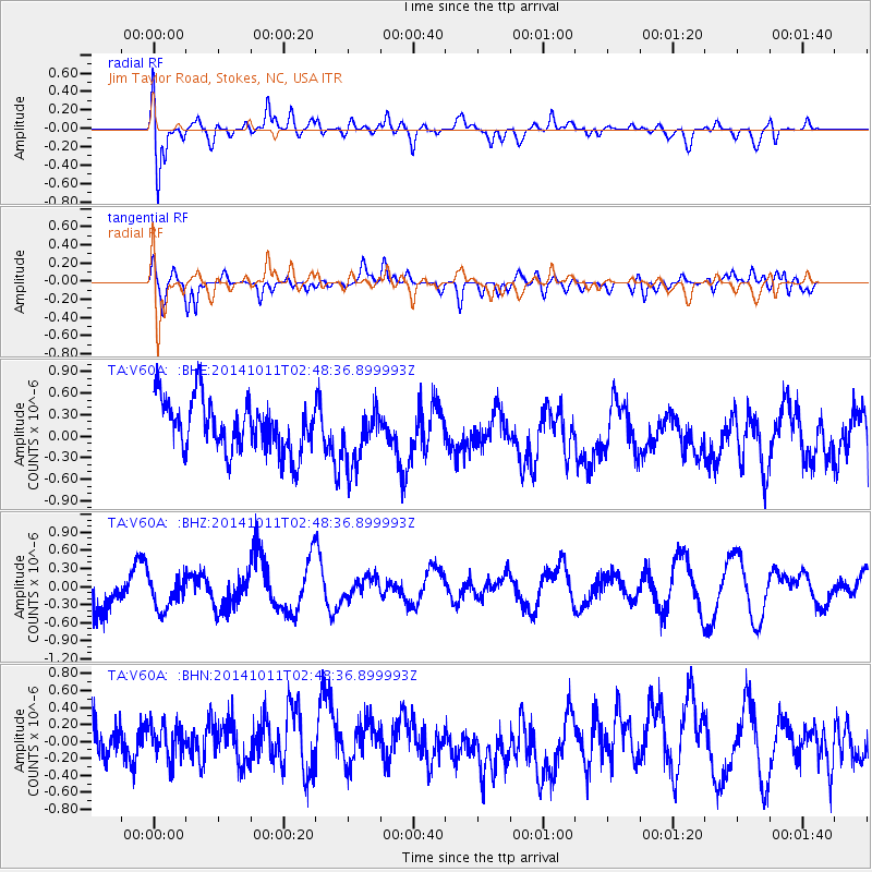
V60A Jim Taylor Road, Stokes, NC, USA - Earthquake Result Viewer
*The percent match for this event was below the threshold and hence no stack was calculated.
| Earthquake location: |
Off East Coast Of Honshu, Japan |
| Earthquake latitude/longitude: |
41.0/143.2 |
| Earthquake time(UTC): |
2014/10/11 (284) 02:35:46 GMT |
| Earthquake Depth: |
14 km |
| Earthquake Magnitude: |
6.3 MWP |
| Earthquake Catalog/Contributor: |
NEIC PDE/NEIC COMCAT |
|
| Network: |
TA USArray Transportable Network (new EarthScope stations) |
| Station: |
V60A Jim Taylor Road, Stokes, NC, USA |
| Lat/Lon: |
35.76 N/77.26 W |
| Elevation: |
8.0 m |
|
| Distance: |
95.1 deg |
| Az: |
32.007 deg |
| Baz: |
330.438 deg |
| Ray Param: |
$rayparam |
*The percent match for this event was below the threshold and hence was not used in the summary stack. |
|
| Radial Match: |
66.68393 % |
| Radial Bump: |
400 |
| Transverse Match: |
56.333504 % |
| Transverse Bump: |
400 |
| SOD ConfigId: |
803114 |
| Insert Time: |
2014-10-25 03:02:16.056 +0000 |
| GWidth: |
2.5 |
| Max Bumps: |
400 |
| Tol: |
0.001 |
|
Signal To Noise
| Channel | StoN | STA | LTA |
| TA:V60A: :BHZ:20141011T02:48:36.899993Z | 0.808011 | 2.6978606E-7 | 3.338891E-7 |
| TA:V60A: :BHN:20141011T02:48:36.899993Z | 0.82351106 | 2.268051E-7 | 2.7541233E-7 |
| TA:V60A: :BHE:20141011T02:48:36.899993Z | 1.114426 | 4.0565692E-7 | 3.6400525E-7 |
| Arrivals |
| Ps | |
| PpPs | |
| PsPs/PpSs | |


