You are here: Home > Network List > TA - USArray Transportable Network (new EarthScope stations) Stations List
> Station W56A Indian Trail, NC, USA > Earthquake Result Viewer
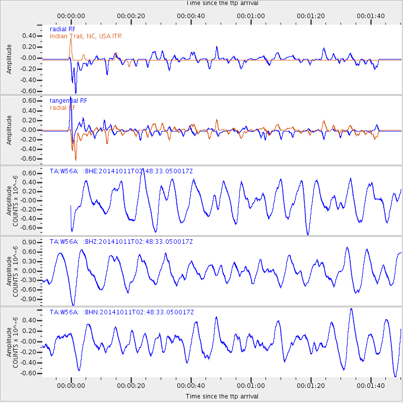
W56A Indian Trail, NC, USA - Earthquake Result Viewer
*The percent match for this event was below the threshold and hence no stack was calculated.
| Earthquake location: |
Off East Coast Of Honshu, Japan |
| Earthquake latitude/longitude: |
41.0/143.2 |
| Earthquake time(UTC): |
2014/10/11 (284) 02:35:46 GMT |
| Earthquake Depth: |
14 km |
| Earthquake Magnitude: |
6.3 MWP |
| Earthquake Catalog/Contributor: |
NEIC PDE/NEIC COMCAT |
|
| Network: |
TA USArray Transportable Network (new EarthScope stations) |
| Station: |
W56A Indian Trail, NC, USA |
| Lat/Lon: |
35.13 N/80.58 W |
| Elevation: |
177 m |
|
| Distance: |
94.2 deg |
| Az: |
34.668 deg |
| Baz: |
328.305 deg |
| Ray Param: |
$rayparam |
*The percent match for this event was below the threshold and hence was not used in the summary stack. |
|
| Radial Match: |
72.25786 % |
| Radial Bump: |
400 |
| Transverse Match: |
62.334698 % |
| Transverse Bump: |
400 |
| SOD ConfigId: |
803114 |
| Insert Time: |
2014-10-25 03:02:24.141 +0000 |
| GWidth: |
2.5 |
| Max Bumps: |
400 |
| Tol: |
0.001 |
|
Signal To Noise
| Channel | StoN | STA | LTA |
| TA:W56A: :BHZ:20141011T02:48:33.050017Z | 1.9880152 | 6.524623E-7 | 3.2819784E-7 |
| TA:W56A: :BHN:20141011T02:48:33.050017Z | 1.4125453 | 2.6603755E-7 | 1.8833911E-7 |
| TA:W56A: :BHE:20141011T02:48:33.050017Z | 0.8948105 | 2.8140516E-7 | 3.1448576E-7 |
| Arrivals |
| Ps | |
| PpPs | |
| PsPs/PpSs | |


