You are here: Home > Network List > TA - USArray Transportable Network (new EarthScope stations) Stations List
> Station H17A Grant Village (NPS), Yellowstone Nt. Park, WY, USA > Earthquake Result Viewer
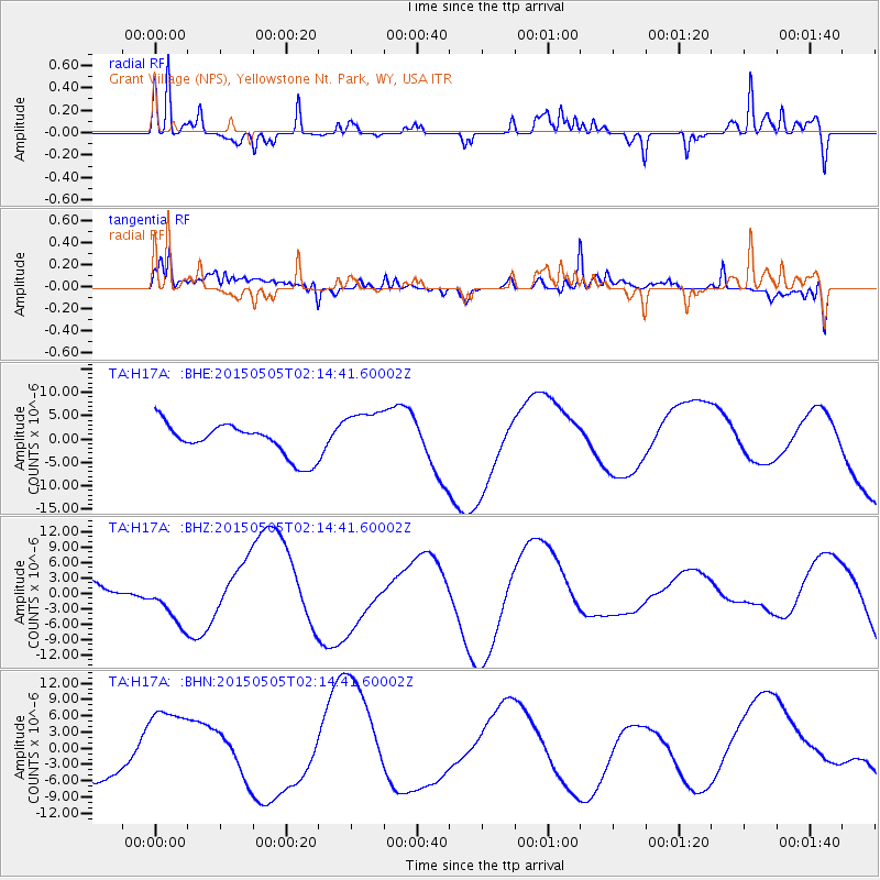
H17A Grant Village (NPS), Yellowstone Nt. Park, WY, USA - Earthquake Result Viewer
*The percent match for this event was below the threshold and hence no stack was calculated.
| Earthquake location: |
Morocco |
| Earthquake latitude/longitude: |
32.3/-6.2 |
| Earthquake time(UTC): |
2015/05/05 (125) 02:03:18 GMT |
| Earthquake Depth: |
14 km |
| Earthquake Magnitude: |
6.1 ml |
| Earthquake Catalog/Contributor: |
ISC/ISC |
|
| Network: |
TA USArray Transportable Network (new EarthScope stations) |
| Station: |
H17A Grant Village (NPS), Yellowstone Nt. Park, WY, USA |
| Lat/Lon: |
44.40 N/110.58 W |
| Elevation: |
2400 m |
|
| Distance: |
77.3 deg |
| Az: |
314.634 deg |
| Baz: |
57.246 deg |
| Ray Param: |
$rayparam |
*The percent match for this event was below the threshold and hence was not used in the summary stack. |
|
| Radial Match: |
83.51656 % |
| Radial Bump: |
240 |
| Transverse Match: |
68.14915 % |
| Transverse Bump: |
400 |
| SOD ConfigId: |
7422571 |
| Insert Time: |
2019-04-18 16:21:35.001 +0000 |
| GWidth: |
2.5 |
| Max Bumps: |
400 |
| Tol: |
0.001 |
|
Signal To Noise
| Channel | StoN | STA | LTA |
| TA:H17A: :BHZ:20150505T02:14:41.60002Z | 1.1218448 | 5.202407E-6 | 4.637368E-6 |
| TA:H17A: :BHN:20150505T02:14:41.60002Z | 2.3992999 | 7.922077E-6 | 3.3018287E-6 |
| TA:H17A: :BHE:20150505T02:14:41.60002Z | 1.5864259 | 5.461269E-6 | 3.4424988E-6 |
| Arrivals |
| Ps | |
| PpPs | |
| PsPs/PpSs | |


