You are here: Home > Network List > TA - USArray Transportable Network (new EarthScope stations) Stations List
> Station L44A Lake County Forest Preserve, Grayslake, IL, USA > Earthquake Result Viewer
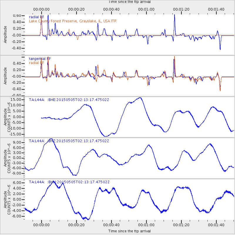
L44A Lake County Forest Preserve, Grayslake, IL, USA - Earthquake Result Viewer
*The percent match for this event was below the threshold and hence no stack was calculated.
| Earthquake location: |
Morocco |
| Earthquake latitude/longitude: |
32.3/-6.2 |
| Earthquake time(UTC): |
2015/05/05 (125) 02:03:18 GMT |
| Earthquake Depth: |
14 km |
| Earthquake Magnitude: |
6.1 ml |
| Earthquake Catalog/Contributor: |
ISC/ISC |
|
| Network: |
TA USArray Transportable Network (new EarthScope stations) |
| Station: |
L44A Lake County Forest Preserve, Grayslake, IL, USA |
| Lat/Lon: |
42.18 N/87.91 W |
| Elevation: |
202 m |
|
| Distance: |
63.5 deg |
| Az: |
304.74 deg |
| Baz: |
69.497 deg |
| Ray Param: |
$rayparam |
*The percent match for this event was below the threshold and hence was not used in the summary stack. |
|
| Radial Match: |
52.787064 % |
| Radial Bump: |
400 |
| Transverse Match: |
54.866978 % |
| Transverse Bump: |
400 |
| SOD ConfigId: |
7422571 |
| Insert Time: |
2019-04-18 16:21:49.164 +0000 |
| GWidth: |
2.5 |
| Max Bumps: |
400 |
| Tol: |
0.001 |
|
Signal To Noise
| Channel | StoN | STA | LTA |
| TA:L44A: :BHZ:20150505T02:13:17.47502Z | 2.976031 | 8.662312E-6 | 2.9106927E-6 |
| TA:L44A: :BHN:20150505T02:13:17.47502Z | 2.0807061 | 3.5046626E-6 | 1.6843621E-6 |
| TA:L44A: :BHE:20150505T02:13:17.47502Z | 2.4809835 | 9.068469E-6 | 3.6551914E-6 |
| Arrivals |
| Ps | |
| PpPs | |
| PsPs/PpSs | |


