You are here: Home > Network List > IU - Global Seismograph Network (GSN - IRIS/USGS) Stations List
> Station CTAO Charters Towers, Australia > Earthquake Result Viewer
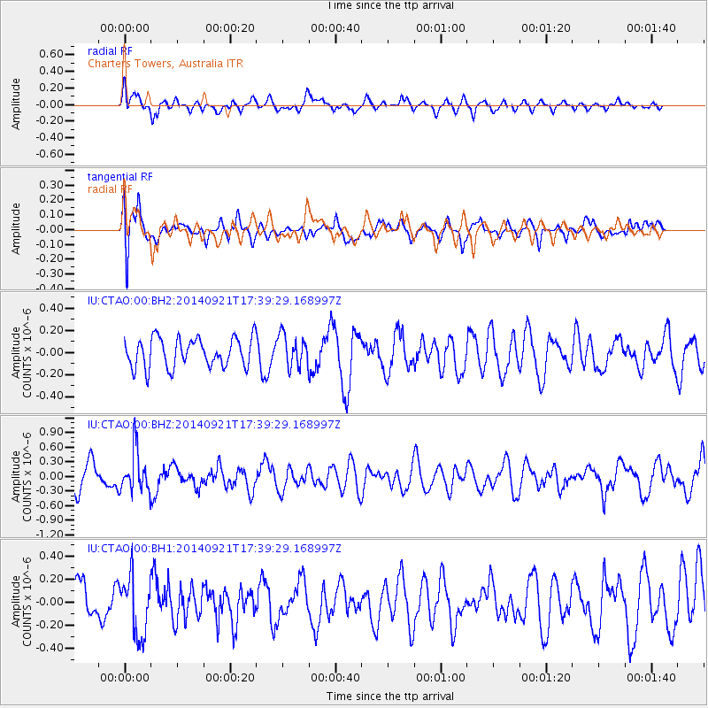
CTAO Charters Towers, Australia - Earthquake Result Viewer
*The percent match for this event was below the threshold and hence no stack was calculated.
| Earthquake location: |
Bonin Islands, Japan Region |
| Earthquake latitude/longitude: |
27.9/139.6 |
| Earthquake time(UTC): |
2014/09/21 (264) 17:32:05 GMT |
| Earthquake Depth: |
491 km |
| Earthquake Magnitude: |
5.5 MWW |
| Earthquake Catalog/Contributor: |
NEIC PDE/NEIC COMCAT |
|
| Network: |
IU Global Seismograph Network (GSN - IRIS/USGS) |
| Station: |
CTAO Charters Towers, Australia |
| Lat/Lon: |
20.09 S/146.25 E |
| Elevation: |
357 m |
|
| Distance: |
48.2 deg |
| Az: |
171.592 deg |
| Baz: |
352.089 deg |
| Ray Param: |
$rayparam |
*The percent match for this event was below the threshold and hence was not used in the summary stack. |
|
| Radial Match: |
60.792915 % |
| Radial Bump: |
400 |
| Transverse Match: |
50.337612 % |
| Transverse Bump: |
400 |
| SOD ConfigId: |
803114 |
| Insert Time: |
2014-10-26 17:08:44.805 +0000 |
| GWidth: |
2.5 |
| Max Bumps: |
400 |
| Tol: |
0.001 |
|
Signal To Noise
| Channel | StoN | STA | LTA |
| IU:CTAO:00:BHZ:20140921T17:39:29.168997Z | 2.0955985 | 4.3016843E-7 | 2.0527236E-7 |
| IU:CTAO:00:BH1:20140921T17:39:29.168997Z | 1.609593 | 2.6107818E-7 | 1.6220136E-7 |
| IU:CTAO:00:BH2:20140921T17:39:29.168997Z | 1.0945575 | 1.4430137E-7 | 1.3183535E-7 |
| Arrivals |
| Ps | |
| PpPs | |
| PsPs/PpSs | |


