You are here: Home > Network List > TA - USArray Transportable Network (new EarthScope stations) Stations List
> Station D04E Lakebay, WA, USA > Earthquake Result Viewer
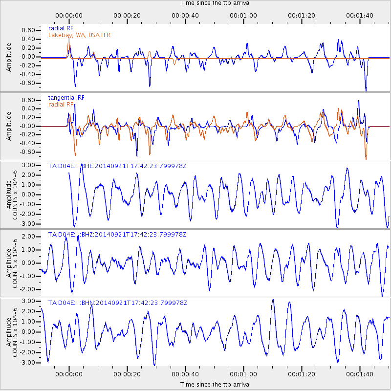
D04E Lakebay, WA, USA - Earthquake Result Viewer
*The percent match for this event was below the threshold and hence no stack was calculated.
| Earthquake location: |
Bonin Islands, Japan Region |
| Earthquake latitude/longitude: |
27.9/139.6 |
| Earthquake time(UTC): |
2014/09/21 (264) 17:32:05 GMT |
| Earthquake Depth: |
491 km |
| Earthquake Magnitude: |
5.5 MWW |
| Earthquake Catalog/Contributor: |
NEIC PDE/NEIC COMCAT |
|
| Network: |
TA USArray Transportable Network (new EarthScope stations) |
| Station: |
D04E Lakebay, WA, USA |
| Lat/Lon: |
47.18 N/122.77 W |
| Elevation: |
45 m |
|
| Distance: |
74.9 deg |
| Az: |
44.454 deg |
| Baz: |
294.729 deg |
| Ray Param: |
$rayparam |
*The percent match for this event was below the threshold and hence was not used in the summary stack. |
|
| Radial Match: |
73.1001 % |
| Radial Bump: |
400 |
| Transverse Match: |
62.14586 % |
| Transverse Bump: |
400 |
| SOD ConfigId: |
803114 |
| Insert Time: |
2014-10-26 17:15:13.995 +0000 |
| GWidth: |
2.5 |
| Max Bumps: |
400 |
| Tol: |
0.001 |
|
Signal To Noise
| Channel | StoN | STA | LTA |
| TA:D04E: :BHZ:20140921T17:42:23.799978Z | 2.1634462 | 1.408876E-6 | 6.512184E-7 |
| TA:D04E: :BHN:20140921T17:42:23.799978Z | 0.686159 | 1.113984E-6 | 1.623507E-6 |
| TA:D04E: :BHE:20140921T17:42:23.799978Z | 0.7282071 | 1.0324859E-6 | 1.4178464E-6 |
| Arrivals |
| Ps | |
| PpPs | |
| PsPs/PpSs | |


