You are here: Home > Network List > TJ - Tajikistan National Seismic Network Stations List
> Station GARM Garm, Tajikistan > Earthquake Result Viewer
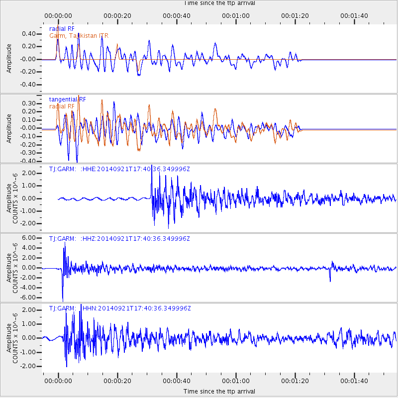
GARM Garm, Tajikistan - Earthquake Result Viewer
*The percent match for this event was below the threshold and hence no stack was calculated.
| Earthquake location: |
Bonin Islands, Japan Region |
| Earthquake latitude/longitude: |
27.9/139.6 |
| Earthquake time(UTC): |
2014/09/21 (264) 17:32:05 GMT |
| Earthquake Depth: |
491 km |
| Earthquake Magnitude: |
5.5 MWW |
| Earthquake Catalog/Contributor: |
NEIC PDE/NEIC COMCAT |
|
| Network: |
TJ Tajikistan National Seismic Network |
| Station: |
GARM Garm, Tajikistan |
| Lat/Lon: |
39.00 N/70.32 E |
| Elevation: |
1305 m |
|
| Distance: |
57.6 deg |
| Az: |
300.309 deg |
| Baz: |
78.59 deg |
| Ray Param: |
$rayparam |
*The percent match for this event was below the threshold and hence was not used in the summary stack. |
|
| Radial Match: |
69.298164 % |
| Radial Bump: |
400 |
| Transverse Match: |
71.12477 % |
| Transverse Bump: |
354 |
| SOD ConfigId: |
803114 |
| Insert Time: |
2014-10-26 17:16:09.032 +0000 |
| GWidth: |
2.5 |
| Max Bumps: |
400 |
| Tol: |
0.001 |
|
Signal To Noise
| Channel | StoN | STA | LTA |
| TJ:GARM: :HHZ:20140921T17:40:36.349996Z | 13.827159 | 1.7569399E-6 | 1.2706442E-7 |
| TJ:GARM: :HHN:20140921T17:40:36.349996Z | 6.9287624 | 6.501573E-7 | 9.383455E-8 |
| TJ:GARM: :HHE:20140921T17:40:36.349996Z | 11.421261 | 7.9553706E-7 | 6.965405E-8 |
| Arrivals |
| Ps | |
| PpPs | |
| PsPs/PpSs | |


