You are here: Home > Network List > US - United States National Seismic Network Stations List
> Station EGMT Eagleton, Montana, USA > Earthquake Result Viewer
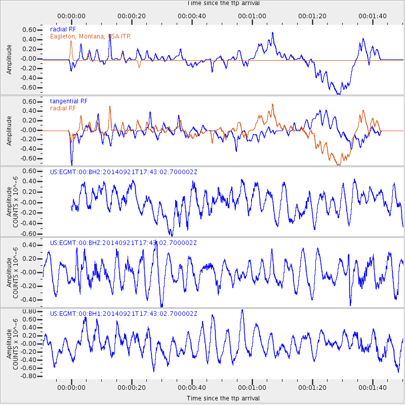
EGMT Eagleton, Montana, USA - Earthquake Result Viewer
*The percent match for this event was below the threshold and hence no stack was calculated.
| Earthquake location: |
Bonin Islands, Japan Region |
| Earthquake latitude/longitude: |
27.9/139.6 |
| Earthquake time(UTC): |
2014/09/21 (264) 17:32:05 GMT |
| Earthquake Depth: |
491 km |
| Earthquake Magnitude: |
5.5 MWW |
| Earthquake Catalog/Contributor: |
NEIC PDE/NEIC COMCAT |
|
| Network: |
US United States National Seismic Network |
| Station: |
EGMT Eagleton, Montana, USA |
| Lat/Lon: |
48.02 N/109.75 W |
| Elevation: |
1055 m |
|
| Distance: |
82.2 deg |
| Az: |
39.351 deg |
| Baz: |
303.314 deg |
| Ray Param: |
$rayparam |
*The percent match for this event was below the threshold and hence was not used in the summary stack. |
|
| Radial Match: |
53.502064 % |
| Radial Bump: |
400 |
| Transverse Match: |
65.67276 % |
| Transverse Bump: |
400 |
| SOD ConfigId: |
803114 |
| Insert Time: |
2014-10-26 17:16:40.113 +0000 |
| GWidth: |
2.5 |
| Max Bumps: |
400 |
| Tol: |
0.001 |
|
Signal To Noise
| Channel | StoN | STA | LTA |
| US:EGMT:00:BHZ:20140921T17:43:02.700002Z | 1.1257972 | 1.7573288E-7 | 1.560964E-7 |
| US:EGMT:00:BH1:20140921T17:43:02.700002Z | 1.4504697 | 3.3064904E-7 | 2.2795997E-7 |
| US:EGMT:00:BH2:20140921T17:43:02.700002Z | 2.5961413 | 4.562587E-7 | 1.7574493E-7 |
| Arrivals |
| Ps | |
| PpPs | |
| PsPs/PpSs | |


